Video Message at the Sixth World Water Forum by H.I.H. the Crown Prince Naruhito of Japan
15 March, 2012
Marseille, France
The following is the original keynote speech by H.I.H. the Crown Prince Naruhito at the Sixth World Water Forum.
Water and Disaster
– Learning from the history of tsunamis –
1. Introduction
I am pleased to be invited to give a key-note speech at the Sixth World Water Forum here in Marseille, the Mediterranean jewel of the French Republic. Unfortunately, due to special circumstances, I can not attend the Forum, and I have to deliver my speech by video. I would like to express my sincere gratitude to the Forum officers who allowed me to make my presentation in this way.
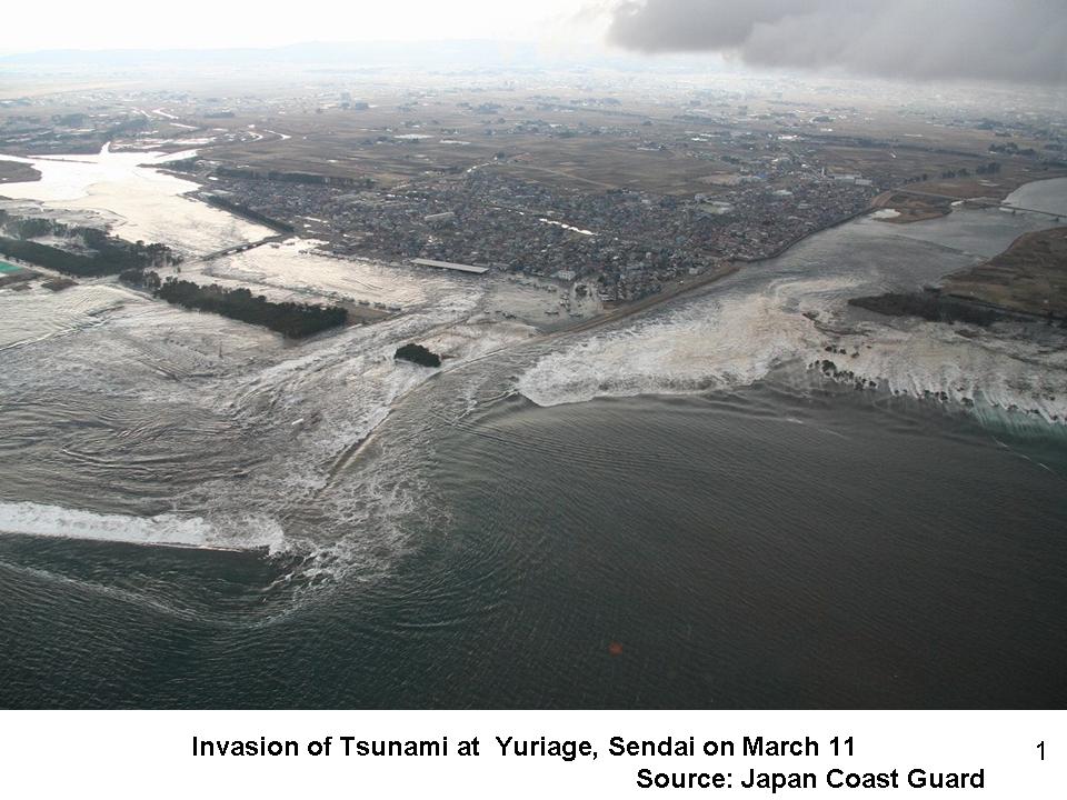
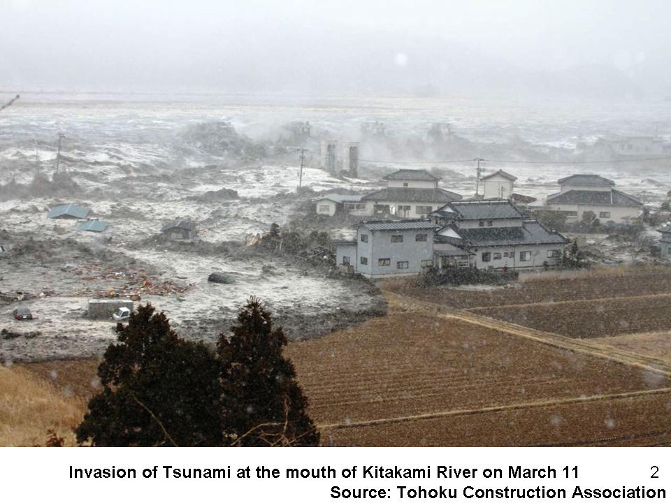
As you know, a mega-earthquake hit Japan one year and four days ago on March 11th, 2011. Tsunamis following the earthquake inflicted a damage of an unprecedented scale to my country; over 19,000 people are dead or still missing (Figure 1)(Figure 2). Here again, I would like to express my heartfelt condolences to those who lost their lives, and my deepest sympathy to those who are affected by the disaster. We are trying our best to recover quickly and reconstruct the affected areas. I would like to express my deep gratitude to France and all other countries that have extended heart-felt messages and help to Japan and our people.
The tsunami is one of the most devastating water-related disasters that may cause catastrophic damage over large areas. In the case of tsunamis, water acts as an agent to bring about disaster although it is not the origin of the natural force. On March 11th last year, many structures and buildings that initially withstood tremors by the mega-earthquake gave in to the following gigantic tsunami, a reminder of the terrible damage water can inflict.
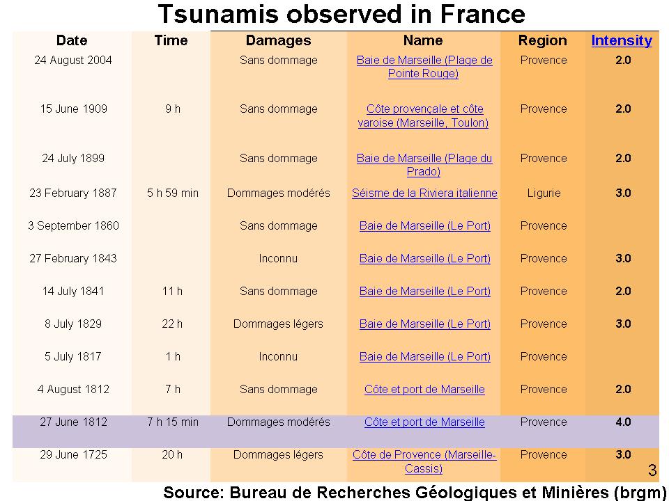
A tsunami occurred here in Marseille, exactly 200 years ago, in June 1812. A number of large ships off the Vieux-Port were damaged by receding tsunami waves. There have been several tsunamis in the past that have caused damage to cities and towns along the Mediterranean coast (Figure 3). I sincerely hope that what I am going to share with you will help you to form a common understanding of this tsunami disaster, one of the most severe water-related disasters.
2. The Great East Japan Earthquake and Tsunamis
Today, my presentation will focus on major tsunamis in Japanese history in order to draw lessons for our future. I shall start from the most recent one, that is, the Great East Japan Earthquake and Tsunami.
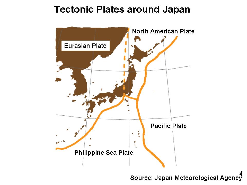
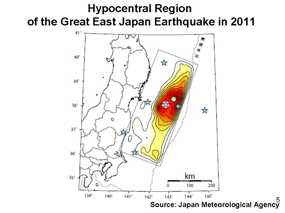
Japan is located near the border of the Pacific Tectonic Plate and the Eurasian Continental Tectonic Plate. As the energy of the moving plate is released at and around the plate border, Japan is often hit by large-scale earthquakes (Figure 4). Epicenters of Great East Japan Earthquake are distributed in a rectangular area of five hundred kilometers from north to south and two hundred kilometers from east to west (Figure 5). Three groups of the hypocentral region are thought to have moved at the same time, leading to the mega-earthquake of magnitude 9.0. The size of the tsunamis far exceeded the tsunami modeled by a forecast simulation.
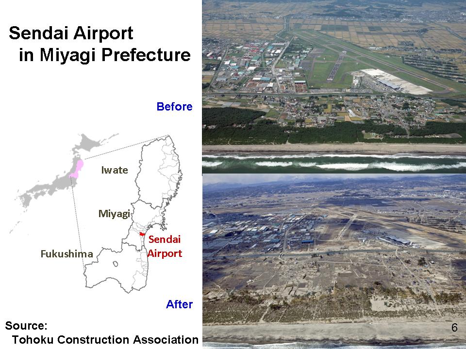
2.1 Sendai Airport
I will now show you some pictures of the disaster affected areas. This picture shows the Sendai Airport of Miyagi Prefecture, a hub airport of the affected region (Figure 6). I landed at this airport on June 4th, 2011 when I visited the affected area. When the airplane started its descent, I was dumbfounded. I witnessed ruined levees off the coast, completely torn-down pine trees along the seashore, and vast barren lands where there ought to have been lively towns and streets.
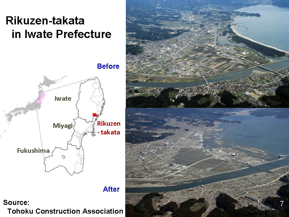
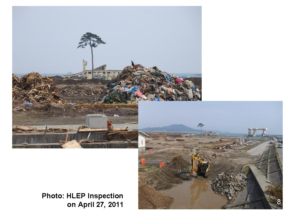
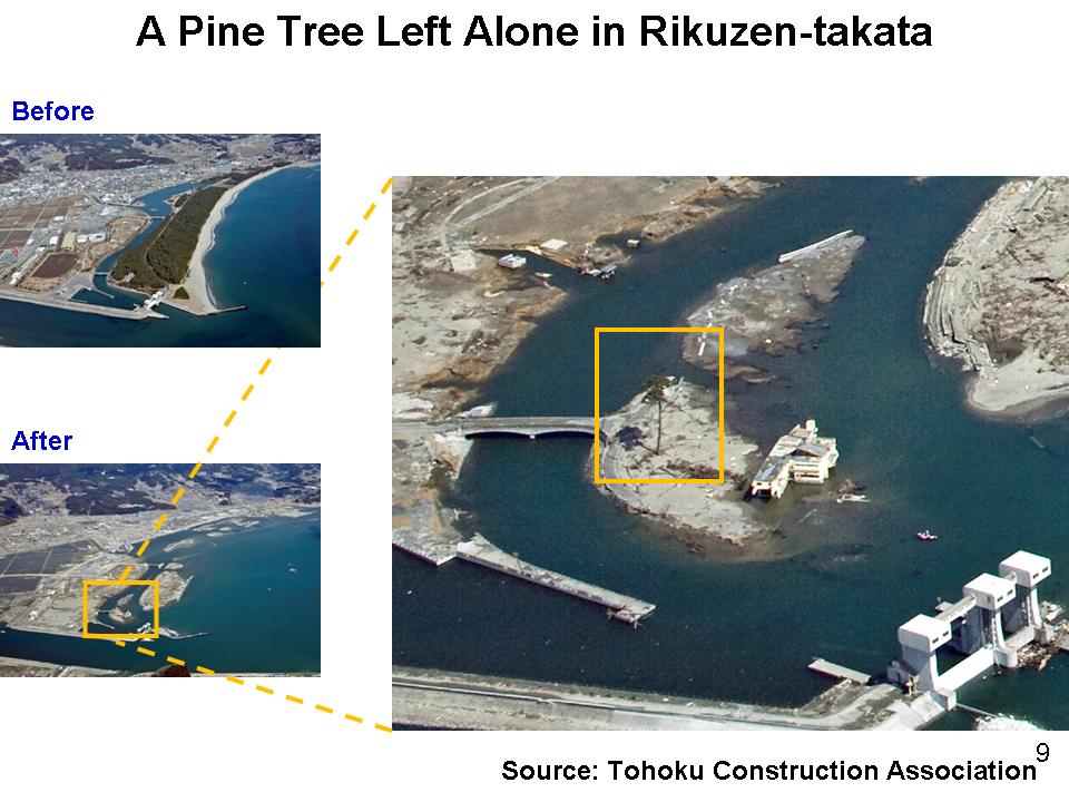
2.2 Rikuzen-takata City
This picture shows the eradicated pine forest area in Rikuzen-takata City, Iwate Prefecture (Figure 7). The Chairman, Dr. Han Seung-soo, and the members of High Level Expert Panel on Water and Disaster visited the city prior to their Tokyo Emergency Meeting in April last year under the leadership of Dr. Han (Figure 8).
I still remember a single pine tree I spotted from the helicopter. It was the only one which survived among thousands, standing alone in the totally devastated town. This tree (Figure 9) has encouraged thousands of people as a symbol of hope. However, this tree is likely to die despite all the efforts of people to protect it.
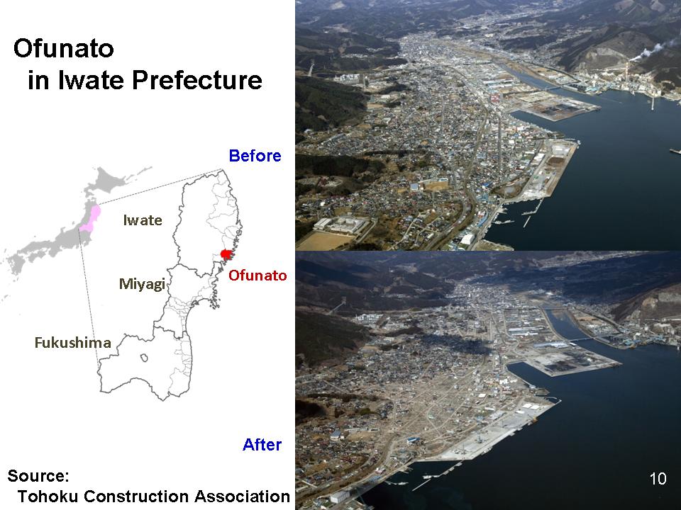
2.3 Ofunato City
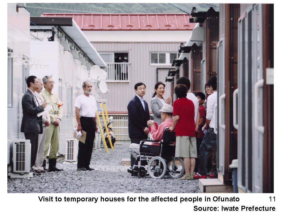
This picture is of Ofunato City in Iwate Prefecture (Figure 10). After disembarking from the helicopter, my wife and I visited the evacuees in Ofunato City, north of Rikuzen-takata. We were deeply impressed by their positive attitude and spirit. Despite all the hardships and inconvenience of living in temporary houses away from home, they were united to help one another, had established a community group, and were overcoming difficulties patiently, and step by step (Figure 11).
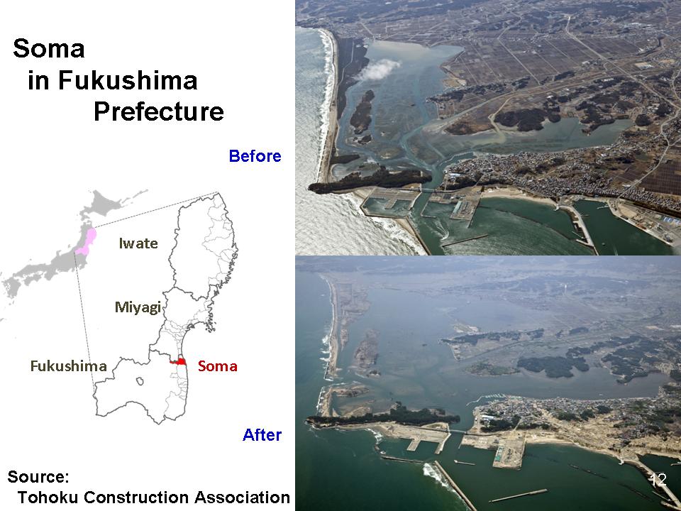
2.4 Soma City
This picture is of Soma City in Fukushima Prefecture (Figure 12). You may notice differences in the extent of damages in pine trees standing in parallel to the coast and those standing at the right angle. It seems that some pine trees have effectively withstood the brunt of the tsunami to some extent but such effects also have limitations.
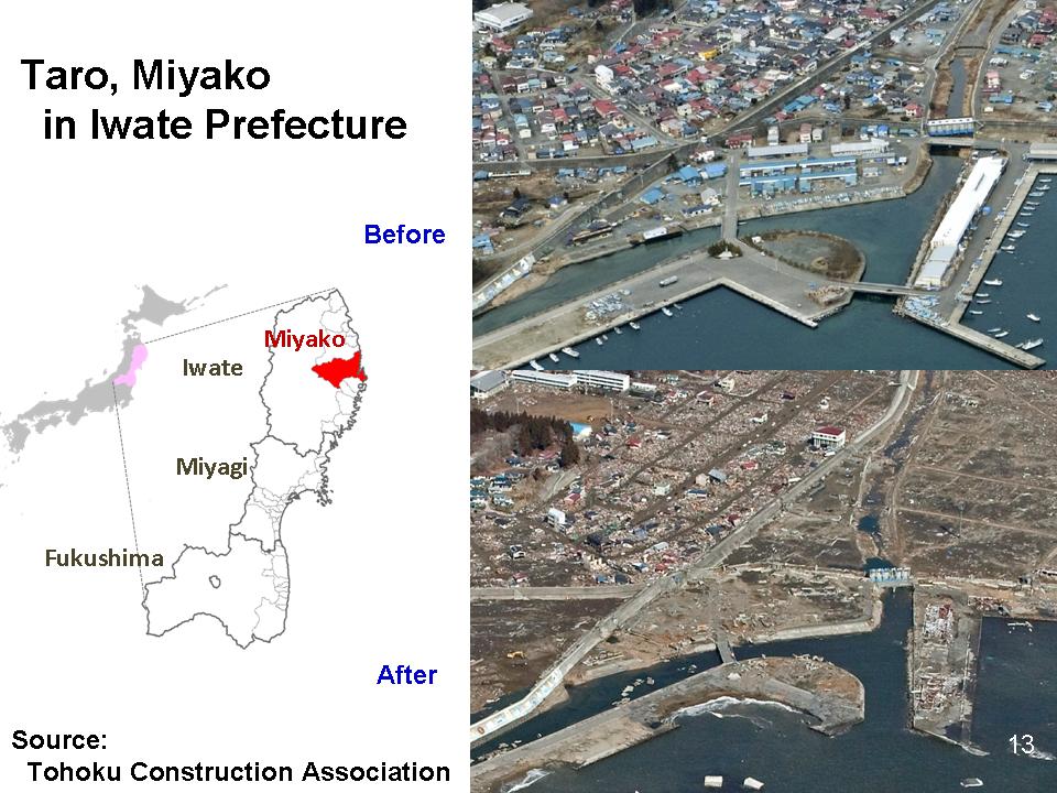
2.5 Miyako City
Last, but not least, I would like to show you a picture of another tsunami-affected area. This is the town Taro in Miyako City, Iwate Prefecture (Figure 13). Taro has been recurrently hit by devastating tsunamis, as in 1896 and 1933. The people rebuilt their towns and homes whenever, and however hard, they were affected by tsunamis. Taro and its people have been literally “living with tsunamis”.
The post-disaster picture shows that the streets on the left spread like a lattice work towards hilly areas. The streets were planned this way to facilitate swift evacuation to higher ground. Such measures had been implemented in tandem with structural measures such as construction of coastal levees. When the Chilean Tsunami mounted the coast of Tohoku in 1960, a total of 142 people lost their lives in the region but none was killed in Taro. The mega-tsunami this time, however, damaged Taro to a large extent.
3. History of tsunamis in Japan
3.1 Why are historical tsunamis examined?
The Great East Japan Earthquake has generated lively discussions on historical earthquakes in Japan. In the discussions, people have focused on the Jogan Earthquake that occurred in 869, around 1,150 years ago, because it was similar in size and was a hypocentral region as the March 11th earthquake. Learning from history is essential when addressing mega-disasters because similar events can be found only after a long span of time.
Inter-plate earthquakes such as the March 11th earthquake are said to occur periodically, as the accumulated energy of tectonic plate is released at certain intervals. An earthquake as large as this has not occurred since the Jogan Earthquake. Therefore, the interval between the earthquakes of this size is assumed to be one thousand years or longer.
On the other hand, the observation of earthquakes in Japan was started only in late 19th century. We have seismic records of just one hundred years which are not enough to understand earthquakes with an interval of one thousand years or longer. We must study history to prepare ourselves for such long interval mega-earthquakes.
Historical reference, archeological evidence, and geological survey records have to be employed to understand details of ancient earthquakes. Availability and quality of the records largely depend on how many years ago the earthquake has occurred.
There remain a number of historical documents on earthquakes and tsunamis in Japan despite the disadvantage that Japanese warehouses and houses, mostly wooden structures, are susceptible to fire. Collecting and analyzing those documents plays a crucial role for advancement of the research. Not only archeological and geological but also historical data are pivotal in ascertaining what has happened. I will touch upon major earthquakes on which the three kinds of data are available, i.e., the earthquakes and tsunamis in 869, 1361, 1498, and 1586.
3.2 The Jogan Earthquake in 869
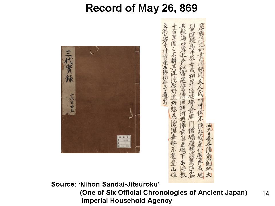
The Jogan Earthquake is described in “Nihon Sandai-Jitsuroku”, one of six official chronologies of ancient Japan. The Jogan Earthquake is the oldest recorded earthquake in the coastal area of the Tohoku Region. The following tsunami brought a catastrophe to the coastal areas of the old Mutsu Province (Figure 14).
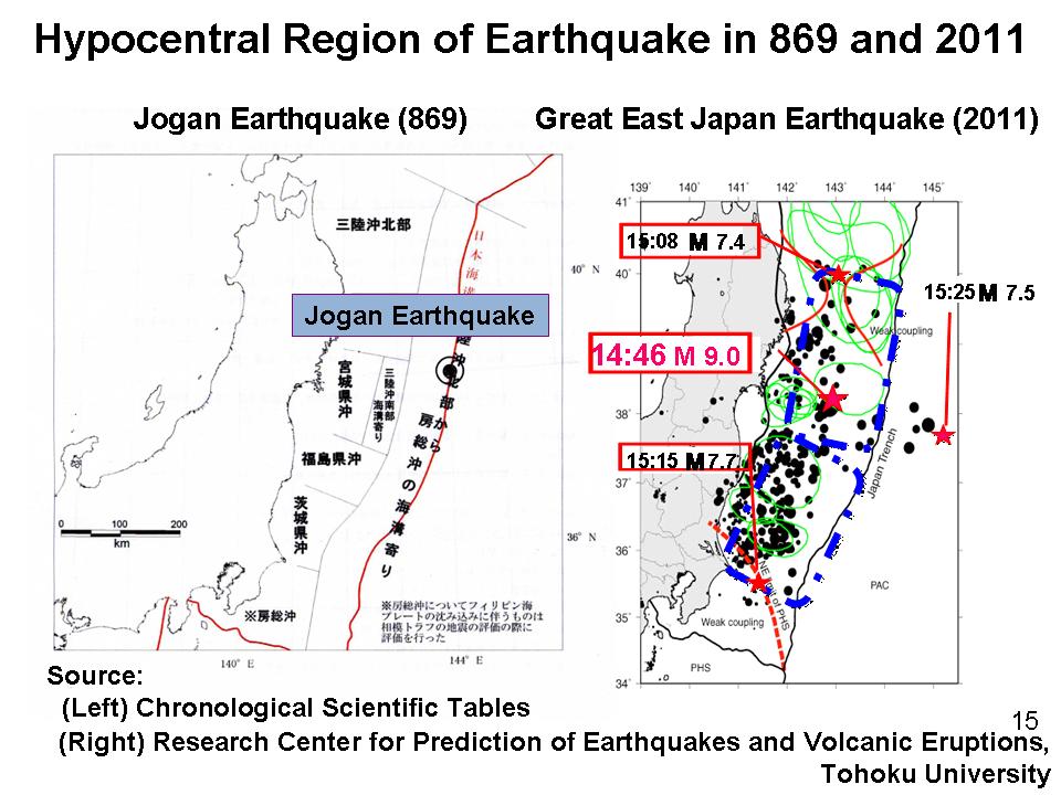
When comparing the Jogan earthquake with that of last year, the affected areas of the two earthquakes overlap as the Jogan earthquake affected the entire area of Mutsu Province whereas the March 11th Earthquake affected the similar area covering the Aomori through to Ibaraki Prefectures (Figure 15). The seismic damage of the Jogan was greater as numerous buildings and houses collapsed, crushing thousands of people to death. The number of deaths by being crushed was relatively small in the March 11th Earthquake. The written description of the Jogan tsunami overlaps with the video picture of the Great East Japan Earthquake. Let me narrate the description of the Jogan tsunami while at the same time showing a video of the tsunami last year.
“The ground of Mutsu Province was violently shaken. There was a howling sound at the sea coast. The sound was like thunder. A great wave boiled up and swirled. Water swelled which instantly reached castle towns. The tide entered tens of miles inland from the coast. It spread over land so vastly that no border could be seen. Fields and roads were all turned into sea. People did not have time to get on boats. They were swallowed up before climbing hills. Thousands of people were drowned. Properties and trees were eradicated. Nothing was left behind.”
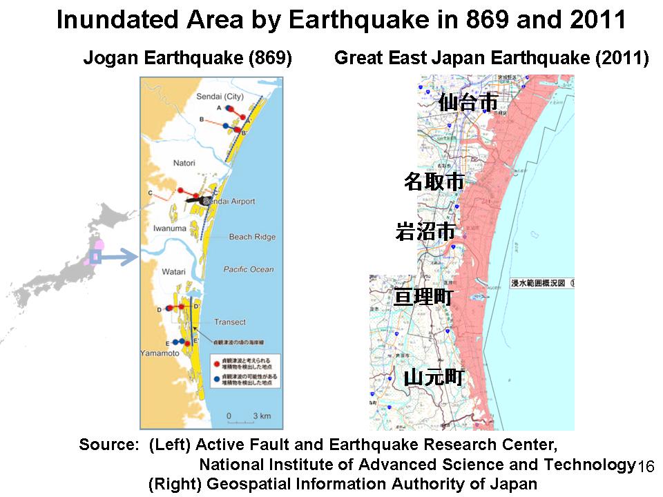
Although this description is the only record of the Jogan Earthquake, it matches with findings of geological surveys. For example, a report by the Active Fault and Earthquake Research Center confirms that the Jogan Tsunami reached 1.5 to 4.0 kilometers inland from the coast. That extent was as far as that of the earthquake last year (Figure 16).
3.3 The Koan Earthquake in 1361
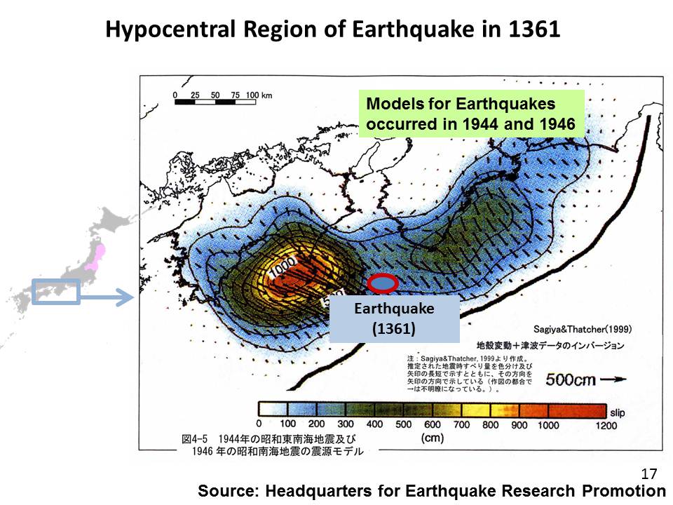
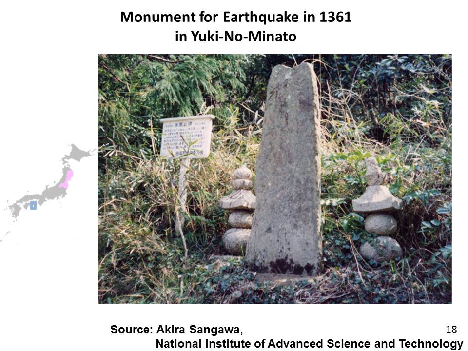
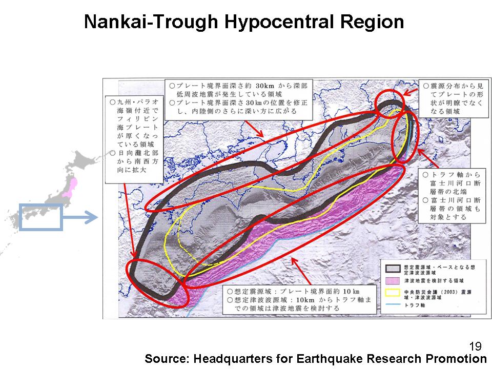
The earthquake and tsunami in 1361 occurred in West Japan (Figure 17). The description of the earthquake is in a war chronicle called the “Taiheiki”. It tells a sad story of the village of “Yuki-no-minato” where 1,700 households were swallowed up by the tsunami (Figure 18). The area including the village is a part of the Nankai-trough hypocentral zone (Figure 19). It is very likely that the tragedy was caused by a mega-earthquake triggered by a movement of a tectonic plate.
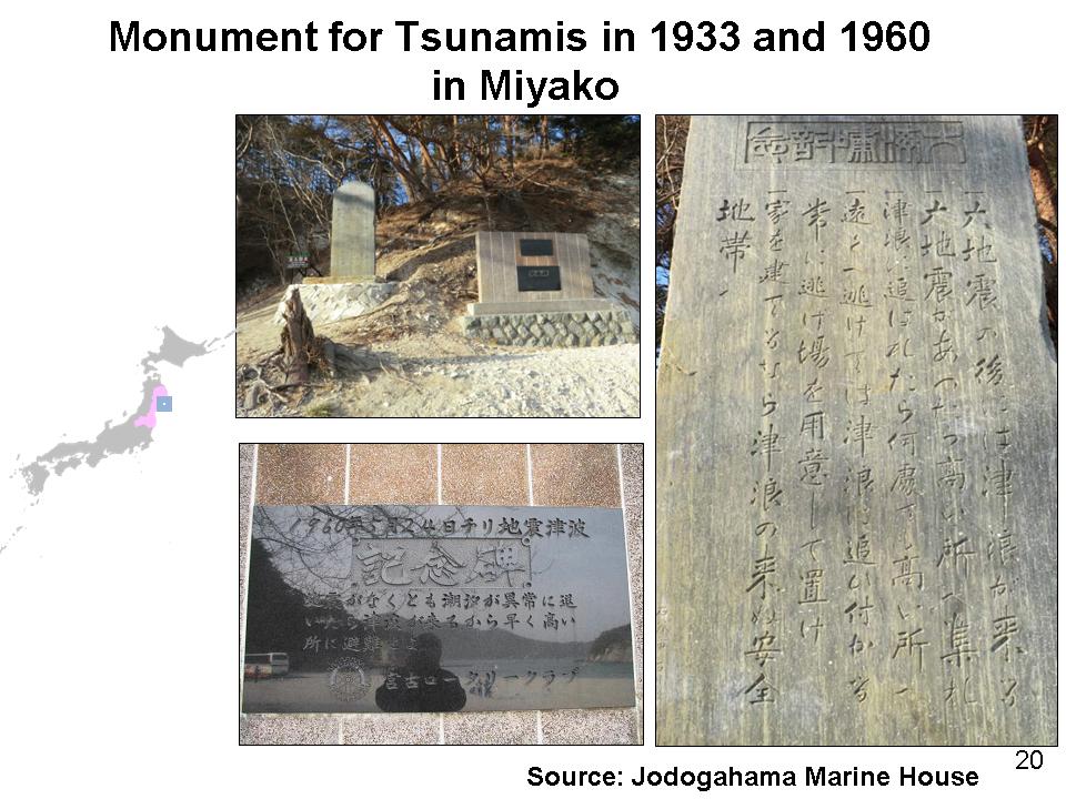
The Taiheiki also tells a sad story of Naniwa-no-ura, Settsu Province. It says, “The receding tide prior to the tsunami onslaught dried up the bay. Hundreds of people who rushed to the dried bay to catch fish were swallowed up by the following mountainous water.” The story reminds me of a tsunami in Japan in 1960. A tsunami caused by an earthquake in Chile across the Pacific Ocean arrived on the east coast of Japan, drowning a large number of people who were unprepared as the earthquake was not felt in Japan. A monument in the affected area says “Even if you do not feel an earthquake, you should evacuate if you see an unusual recession of the sea water.”
Interestingly, the monument in memory of the 1960 tsunami stands next to another monument established right after the tsunami in 1933 (Figure 20). The older monument says “A tsunami follows a big earthquake. Evacuate to higher ground immediately if you feel a strong shake.” Though the two messages do not contradict each other, we tend to misinterpret the latter message as “A tsunami does not come without an earthquake.”
When we try to learn from past lessons, we need to think under what conditions the lessons apply. If not, incorrect interpretations of lessons may lead to wrong actions.
One of these two monuments was unfortunately washed away by the tsunami on March 11th, proving the unprecedented scale of tsunamis.
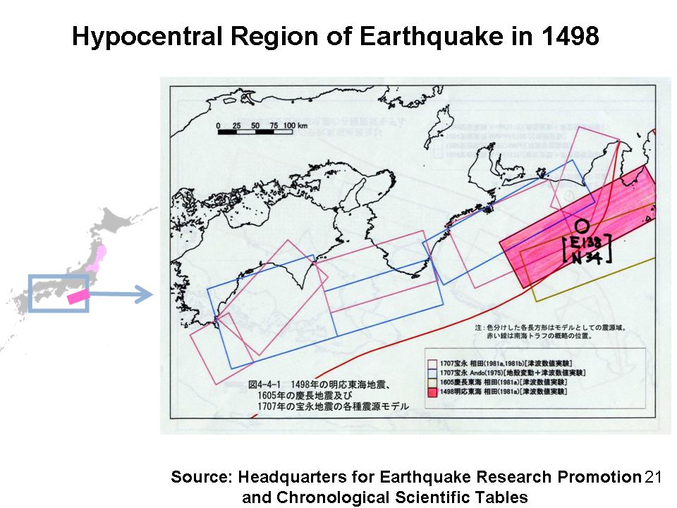
3.4 The Meio Tsunami in 1498
I have talked of the damages caused by tsunamis. But are there historical lessons on recovery and reconstruction?
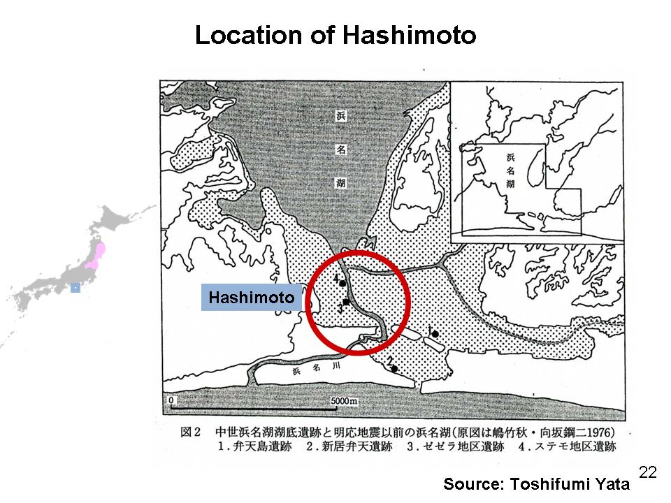
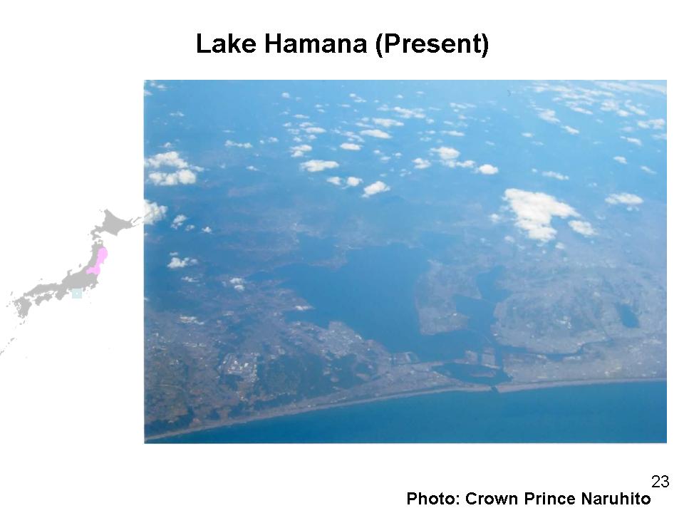
The tsunami in 1498 inflicted substantial damage on Ise and Lake Hamana (Figure 21). The port town of Hashimoto that nestled Lake Hamana was annihilated by the tsunami in 1498 (Figure 22). The once-prosperous port town lost its position when the geographical conditions of the lake were completely changed due to the earthquake. The outlet of the lake was widely opened by the tsunami, which turned fresh lake water into brackish water (Figure 23). The flourishing port town Hashimoto had vanished, but the port itself was reconstructed in a different location, nearby town, Imakiri/Arai.
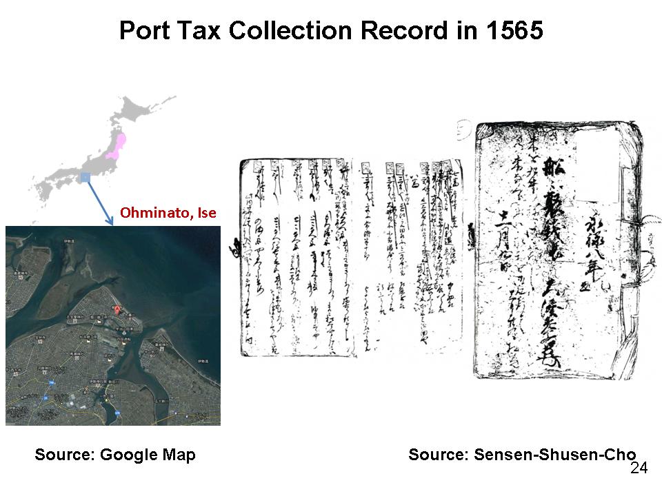
Another port town, Ominato in Ise, was severely affected by the same tsunami in 1498, but followed a different course. The tsunami swept away 1,000 houses and 5,000 people from the town. The port, however, recovered from the devastation. The port tax collection record of 1565 happens today to remain in our hands (Figure 24). It reveals that 67 years after the tsunami, the port town seemed to have fully recovered, as 120 ships entered the port that year. The record shows that the cargo ships to and from the port went as far as a few hundred kilometers from the port.
We have to wait for further studies to know why the two port towns followed different courses. Nevertheless we may expect to find hints for a better future recovery by looking at recovery records of the past.
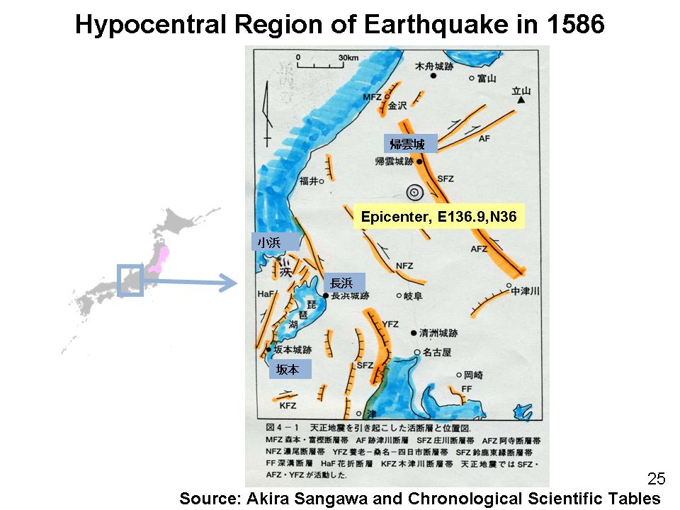
3.5 The Tensho Tsunami in 1586
The tsunami that hit central Japan in 1586 was recorded not only by Japanese but also by foreigners who happened to be in Japan at that time (Figure 25). In the years between 1543 and 1616, European Christian missions could freely stay and travel in Japan to some extent. A Christian Missionary to Japan (Luis Frois) wrote to an archbishop in India (Valignano), “A large city was hit by a great tsunami. When it receded, the tsunami drew with it hundreds of houses and people. All of them were drowned and nothing remained.”
Similar accounts were recorded in the diary of a priest of the Yoshida shrine in Kyoto. He recorded that a tsunami in the coastal provinces in the vicinity of Kyoto swept away many houses and people. The two international and domestic records coincide in the narratives of the large tsunami.
The mystery is that the hypocentral region of the earthquake in 1586 seems to be inland according to a seismological survey, which makes the occurrence of a tsunami from the sea implausible. We will have to wait for further studies to disentangle the contradiction between historical records and seismological conclusions.
3.6 Lessons learned from the history of tsunamis
I have described a few historical cases of major tsunamis which might be useful for discussions on water and disaster. Now comes the question of what we can learn from the past disasters.
As we have seen in these examples, historical records of past disasters give us clues for better future action. They may give hints of the likely size and possible damage from future mega-disasters. Practical lessons on how to react and respond to disasters may be learned by carefully examining and analyzing past experiences. The keys to successful recovery and reconstruction can be analyzed using past records. These lessons are useful even though historical records are sometimes not as accurate and detailed as we would hope. In order to be better prepared for future disasters, we should remember the experience of disaster, and hand them down to our descendants.
I believe, however, the most significant lesson is that our ancestors have faced, struggled, and overcome similar difficulties as we now have. Despite enormous losses, problems and sadness, we are encouraged to move forward because our society has been built on such unrelenting efforts of the people to mitigate and recover from disasters.
4. Addressing water and disasters in the world
While we need some more time to collect and interpret historical lessons for our future actions, more challenges lie ahead of us.
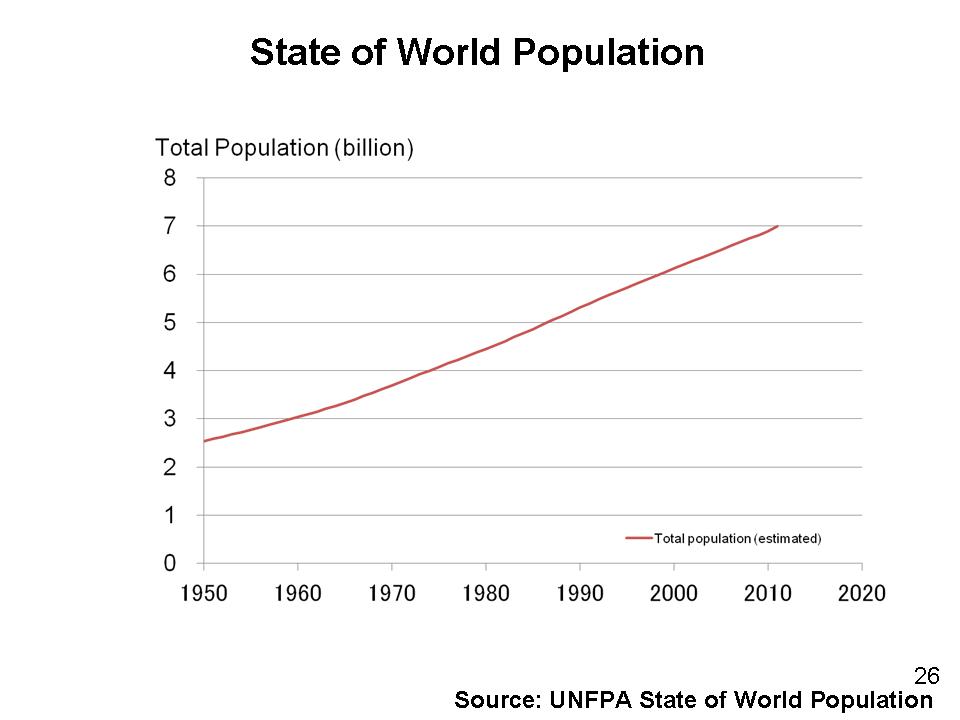
The United Nations announced in 2011 that the world population exceeded 7 billion. It reached 6 billion only 13 years ago (Figure 26). The rapid increase of population accelerated marginal use of freshwater. As a result, minor fluctuations of rainfall result in acute pressure on people and society. The pressure also tends to force people to live in flood-prone areas which they had formerly avoided, which might lead globally to the increased frequency and damage from floods.
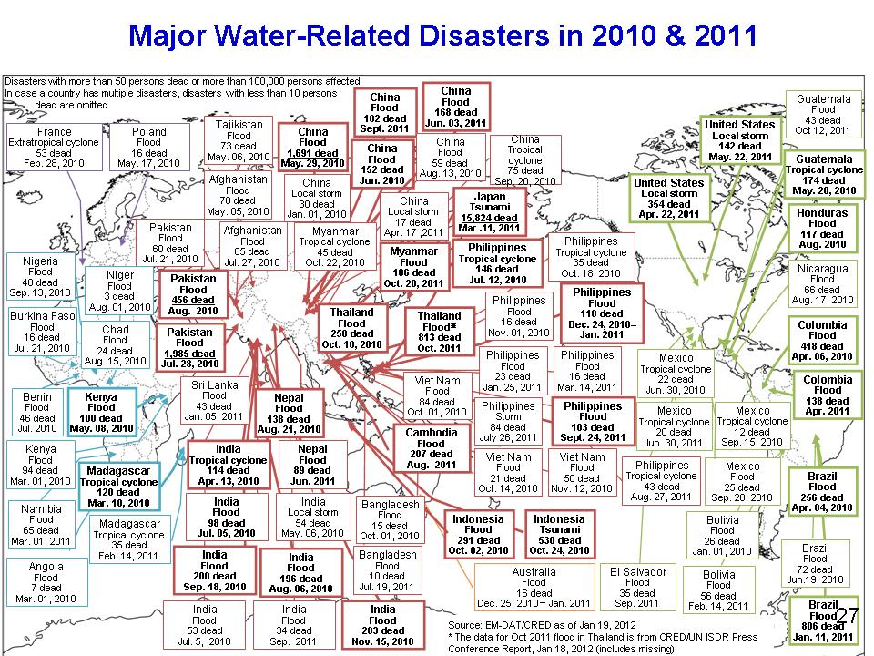
As shown in the inventory of recent disasters, many severe disasters are occurring globally (Figure 27).
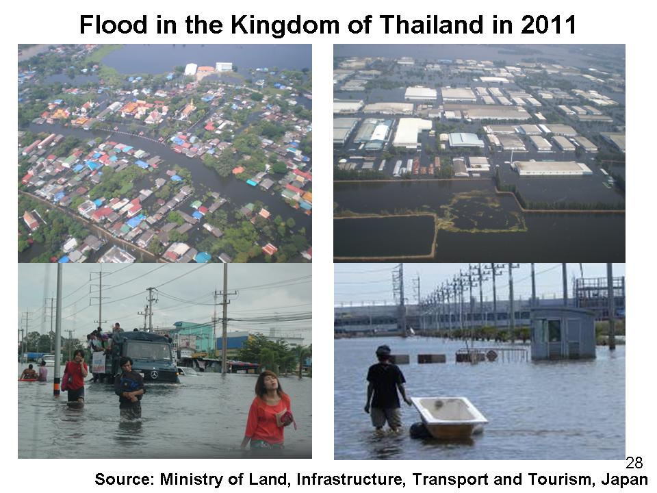
The floods in the Kingdom of Thailand have drawn intense attention of the international community (Figure 28). The water in the Chao Phraya River flooded many cities and towns including Bangkok. Discontinuation of industrial operations due to flooding affected the economy not only at the national level but also had impacts at the regional and global levels. We learned that the impact of disasters easily cross national borders and hinder the sustainable development of other countries, regions or even the world.
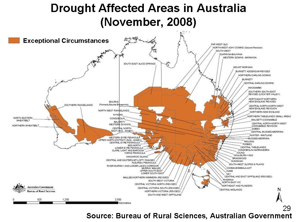
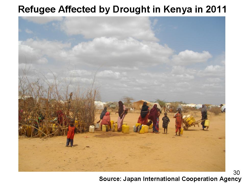
A severe drought in Australia that started in 2006 and 2007 continued in some parts of the country until 2010 (Figure 29). Large scale agricultural damage was recorded. The drought contributed to a sharp hike in the price of agricultural products, encouraging debates on sustainable development under the pressure of population growth on a global scale. Severe drought is happening in Sub-Sahara Africa where tens of thousands of people and children are suffering (Figure 30). We have learned that disasters are an integral part of a complex equation among food, energy, environment, and other key conditions that determine the stability and sustainability of the world.
Whenever we experience unprecedented disasters, we feel a need to seek guidance from the past. We feel this more so as we live in a world where natural and social conditions are more complex and interdependent. Historical lessons and experiences can be used to build a disaster-resilient society under slogans such as “living with water-related disasters”.
Water related disasters are one of the key urgent issues which the international community should address squarely for globally sustainable development. Disasters strike when we least expect them. I will do my best, together with you, to share and make use of the experience and lessons in Japan and elsewhere in order to help build a safer and better future for all.
Thank you.
To a list of documents(Open this content in a new window)