Keynote Lecture at The Fifth World Water Forum by H.I.H. Crown Prince Naruhito of Japan
17 March 2009
Sütülce Congress and Cultural Center
Istanbul, Turkey
Interacting with Water
– Close Ties between Humans and Water –
1. Introduction
I am really happy for this opportunity to give the keynote lecture at the Fifth World Water Forum prior to the “High Level Panel on Water and Disasters”.
High level panels will dedicate four days to address five crucial issues of water as part of the World Water Forum. To start off, this panel will take up the subject of “water and disasters” today. This is an issue that requires our serious commitment for our sustainable development along with drinking water supply and sanitation.
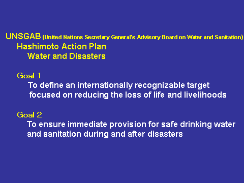
“Water and disasters” is identified as one of the high priority issues in the Hashimoto Action Plan put together under the guidance of the United Nations Secretary General’s Advisory Board on Water and Sanitation (UNSGAB). As many of you know, the chapter on water and disasters in the Action Plan has two goals: the first is to establish a clear-cut target that articulates the direction of global actions for reducing the loss of life and livelihood caused by water-related disasters, and the second is to provide adequate safe drinking water and sanitation during and after disasters (Figure 1).
The High-Level Expert Panel on Water and Disaster was established in September 2007 under the founding chairmanship of Prime Minister Han Seung-soo of the Republic of Korea. For the last year and a half the Panel has engaged in serious deliberations. At this Forum the Panel is expected to make public a document describing the final outcome of their work and to discuss how the recommendations contained in it could be implemented. I very much look forward to hearing their recommendations and seeing their successful implementation.
Against this background, I too would like to focus on “water and disaster” and share with you some timeless practical wisdom nurtured and applied in Japan from the historical perspective which is my field of study. It should tell us of close ties between humans and water.
2. Karako and Kagi ruins
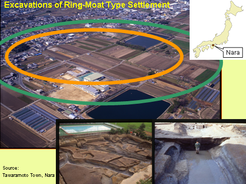
Please look at this photograph (Figure 2). This was where the ring-moat settlements of the Karako and Kagi ruins were discovered in Nara, the ancient capital of Japan. The settlement was surrounded by multiple ring-shaped moats, the bigger ones over eight meters wide. This picture shows a reconstruction of the settlement according to an investigative excavation. At its height of expansion, it is known that it covered as much as forty-two hectares (Figure 3).
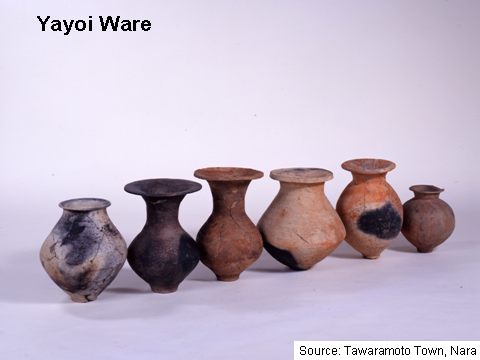
It is believed that at the latest, by the 6th to 4th century B.C., an advanced form of rice-paddy cultivation was established in Japan. As the rice-paddy farming brought over from the Eurasian continent expanded northwards, the farming lifestyle took root from the earlier livelihood of fruit gathering, fishing and hunting. This agricultural culture called the Yayoi culture produced popularly used Yayoi ware and it was at this time that the use of iron and bronze ware began (Figure 4). The Yayoi period lasted until the 3rd century A.D.
The ring-moat type of settlement is said to have originated in the Yangtze River midstream Basin on the Eurasian continent. After reaching Japan, it was prevalent widely throughout the country and is known as characteristic of the period (Figure 5). We know from excavations that ring-moat type of settlement of the Karako and Kagi ruins was the largest in scale and continued to develop throughout most of the Yayoi period. Excavated goods and ware suggest that the Karako and Kagi settlement traded widely with far reaching regions of the country and was a representative center of the period and known as a “Yayoi city”.
The purpose of the moats has not yet been clearly identified but they are variously considered to have been built to defend the settlements from enemies and predatory animals, for irrigation and as canals for transportation and as a defense against floods. It is reasonable, therefore, to suppose that they were created for multiple purposes. It may well have been that different settlements had different purposes in using the moats.
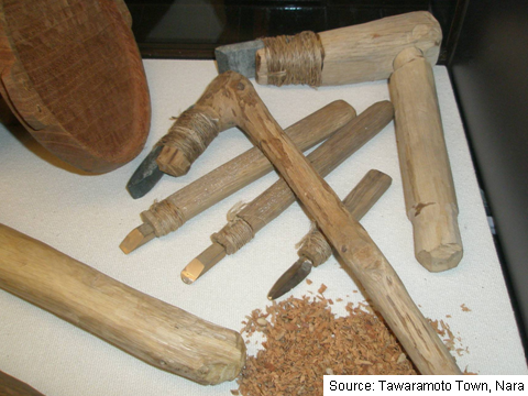
In any case, it appears certain that the people of this period tried their hand at managing water. Paddy cultivation requires abundant water. But if one descends to lowlands for water one must be prepared for the danger of flooding. Water management demands an organized work force and multifarious tools. Archaeologists working in the Karako and Kagi ruins have unearthed tools made of stone and wood, and even iron axes suggesting the high productivity of the settlement (Figure 6).
At a time when stone and wooden tools were used for engineering works, people chose to work and build on soft ground. It was thus that the Karako and Kagi ruins were located on alluvial soil created by the turbulent flow of the Yamato River. The soft soil was ideal for the purpose of drawing water as one could dig with little effort, and it is also well suited for building ring moats.
Understandably, the flat and fragile alluvial ground constantly exposed the inhabitants to the fear of flooding. The ring-moats, therefore, can be said to have played the role of reducing flood damage by functioning as flood retarding ponds.
It is also known that ring-moats were polluted with roundworms and whipworms. Most likely the moats were the dumping area of waste water. It is quite possible to imagine that they provided simple water treatment function just like lagoons found throughout Southeast Asia.
Thus the ring-moat settlements of the Yayoi period already had to grapple with the present day priority issues of disaster from floods and water supply and sanitation.
These settlements appear gradually to have expanded by integrating surrounding settlements in the course of fighting over water which was essential for agriculture. In this way, large domains were built on lands favoured with water.
A sense of nationhood is often said to originate from conflicts over boundaries, so it is interesting to note that in ancient Japan a sense of nationhood was most likely born of the relationship between humans and water, as we have seen in the ring-moat type of settlement. Above all, I would like to take note of the incessant efforts made to maintain ring-moats which made co-existence with water possible and for the essential further development of their communities.
3. Battle against the Tone River
Next let us take a look at the more recent history of the battle between the inhabitants and the waters of the Tone River as a consequence of which the foundation was built for the development of Greater Tokyo Metropolitan Area.
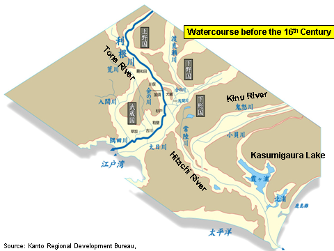
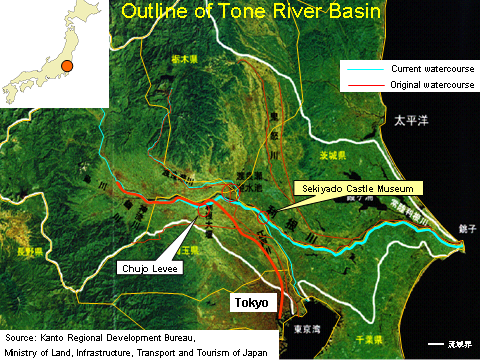
The Tone River has the largest basin in Japan today and serves as an important source of water supporting the livelihood and industrial needs of the capital area (Figure 7). In pre-modern times (before the 16th century) the river followed in quite a different course from its current course.
(1) The Tone River in ancient times
Once, the Tone River rushed down from Honshu’s mountain backbone to the plains where it slowed and meandered before emptying into Tokyo Bay. The River Kinu, now a branch of the Tone, was then separate from it and belonged to the Hitachi river system that flowed into the Pacific Ocean through what was then an inland sea, the present Kasumigaura Lake (Figure 8).
The first river improvement work that appears in historical records was around the middle of the eighth century when excavations were made to straighten the sinuous course of the Kinu River (Figure 9). An aerial photograph reveals clearly the work accomplished 1,250 years ago (Figure 10). So the old imprint of the river left in the ground was not easily erased.
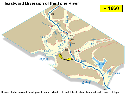
(2) Eastward diversion of the Tone River
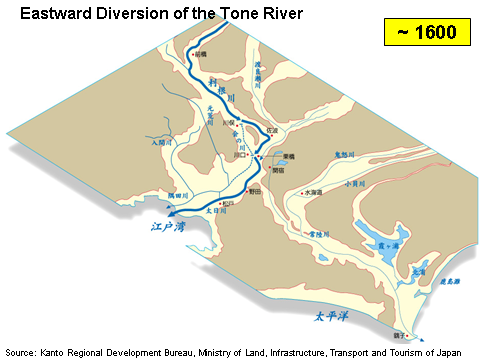
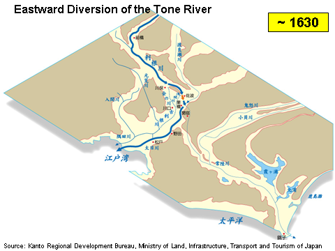
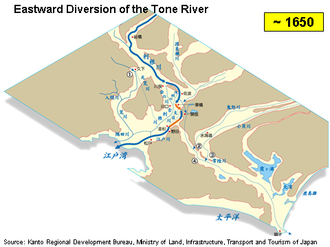
River works were carried out from time to time on the Tone and Hitachi rivers. The mammoth project was the eastward diversion of the Tone River completed in modern times.
Japan was unified in 1590 under General Hideyoshi Toyotomi (1536-1598) who put an end to a warring period that had lasted a hundred years. His rival Ieyasu Tokugawa (1542-1616) was movedto the Kanto region, making his base in Edo (present-day Tokyo). There he launched a bold project to divert the Tone River to ensure the safety of the inhabitants from flooding. The work called for the Tone River to be gradually diverted towards the Hitachi River that lay to the east and away from its original watercourse to flow directly into the Pacific. The main project took approximately sixty years to complete, from 1594 to 1654 (Figure 11-1) (Figure 11-2) (Figure 11-3) (Figure 11-4) (Figure 11-5).
Meanwhile, after the death of Hideyoshi, and his decisive victory at the battle of Sekigahara in 1600, Ieyasu led the government in Edo as the first Tokugawa shogun. Originally envisioned by Ieyasu to improve the safety of his castle, the eastward diversion of the Tone River progressively took on the nature of a national project to support the capital which was to develop into one of the world’s largest cities.
There are differing accounts of its original purpose, but in the end the project served not only for flood control, but also for new paddy development, inland navigation, military defense and facilitating the building of trunk roads. The eastward diversion of the Tone River thus without doubt helped lay the foundation for the ensuing development of Edo.
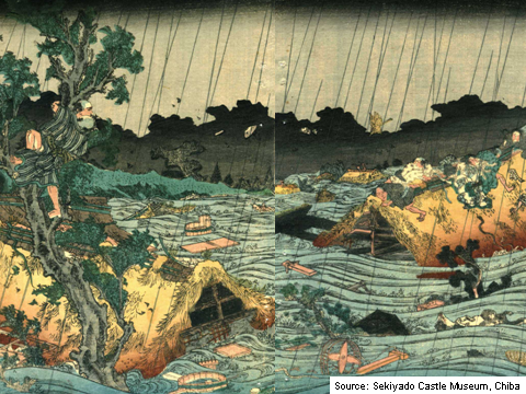
This does not mean that people were entirely free from flood damage after the completion of the work of diverting the Tone River. Including smaller ones, there were altogether 173 floods during the 265 years of the Edo period, with major occurrences about every forty years. When big floods started upstream, the floodwater would surge down the old riverbed into Edo, causing huge damage (Figure 12). The Tone River was terribly difficult to control requiring sustained efforts to improve safety.
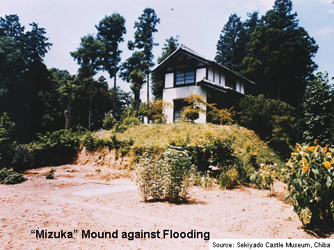
For this reason, people who lived in the midstream basin of the Tone River built mounds by piling up earth and/or planted trees to defend their livelihoods from water-related disasters (Figure 13). “Mizuka” mounds, as they were called, not only protected family and their property but also helped neighbors, who did not have their own water shelter as well as their domestic animals. Once a flood occurred people were often forced to take refuge in their mound for a period of time. Therefore, food and wares necessary for living were also stored there. Small boats were kept in the main house for relief and salvage operations and to transport goods in case of flooding.
(3) Chujo Levee
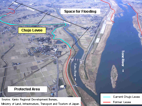
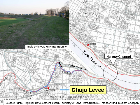
I recently paid a visit to the middle of the Tone River to see what might still be found there of what our people achieved in the past. One of the constructions I saw is known as the Chujo Levee (Figure 14). It is not known exactly when this levee was built, but it is considered to have existed for at least four hundred years.
From this point the Tone River descends more gently, and downstream it narrows so that floodwater tended to back up and be contained upstream instead of continuing its downstream momentum (Figure 15). Once it flooded and overflowed its levees, the unrestrained floodwater inundated the low-lying plain from Saitama to Tokyo Bay. This presented a major challenge for flood control.
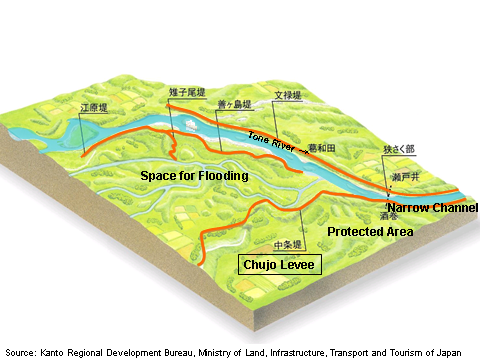
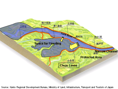
Between the Chujo Levee and the left bank of the river (the Bunroku Levee) a funnel is formed that directs the flow back into the open space created between it and the right bank (the Zengasima Levee), thus retarding water flow. This reduces the risk of flooding downstream. Part of the right bank (the Zengasima Levee) in the middle of the river was designed to be lower than the levee as well as the left bank (Bunroku levee) itself so as to let the floodwater run over it. The plains of Saitama and Edo were protected from flood damage thanks to the retarding function of the levee. (Figure 16-1) (Figure 16-2) (Figure 16-3) (Figure 16-4)
Nonetheless, the Chujo Levee came to be known in the Edo period as “the controversial levee”, because of the interminable disputes between the upstream and downstream communities. After it was breached in the heavy flood of 1910, the controversy became so intractable that the Chujo Levee was never fully repaired, ending its pivotal role of managing the Tone River flood. It was, however, left so as to be able to function as a reserve levee in the event that the embankment of the Tone River was compromised. This is one example of old wisdom continuing to serve its usefulness to this day.
Discontinuation of the flood abating role of the Chujo Levee, as expected, had a large impact on the Tone River flood control system. After numerous discussions, it was decided to continue projects to increase the safety of the whole Tone basin. Today, in addition to the basic approach to ensure the integrity of the whole levee, water is detained in upstream dams as well as in retarding basins in the lower reaches of the Tone River to complement the flood containing capacity of the river in the event of a large-scale flood.
(4) Fear of the river
We have seen how the Tone River was once forced to change its course at the hands of humans. Looking at the Tone River today it is easy to fool ourselves into imagining that we can control with our puny hands the wild animal that a river is. We are surely mistaken. We would be far better off to come to terms with the unwelcome reality that a river can sometimes turn into a savage beast.
Even in recent times, the havoc caused in 1947 by Typhoon Katherine is still deeply etched in our memory. The typhoon broke the right bank of the Tone at the crucial Kurihashi point, the lifeline of the Eastward Diversion project, severely harming the people still reeling from the devastation of World War II (Figure 17). Once the Tone River overflows, the water tries to return to the old channel that existed before the diversion. According to one projection, in the event that rains on the scale experienced in Typhoon Katherine were to hit the area again, 6,300 people would lose their lives and 1.1 million would be isolated.
That is why there is ongoing work being conducted on the Tone River such as expanding the levee width and creating a retarding basin to ensure that flooding is managed even under assault by another equally powerful typhoon.
(5) Co-existence with the river
Management of a river requires much more than building and maintaining modern facilities as responsible governments have done. It requires putting creative minds together to chart a long-term vision for its whole basin, mindful of its peculiar geographic conditions as well as the particulars of its historical relations with people. In the case of the Tone River, there has been a lengthy conflict between the people living upstream and those downstream. This would have been much more of a challenge if it had been an international river running through a number of countries.
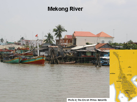
I watched the ever-lastingly flowing Mekong in Vietnam last February (Figure 18). I learned that multilateral cooperation was proactively pursued by the riparian countries in order to resolve the many challenges in the basin, as seen in activities by Mekong River Commission composed of the four downstream countries. I sincerely hope close cooperation develops in the basin. The visit reminded me how important it is for inhabitants to learn about their rivers and basins.
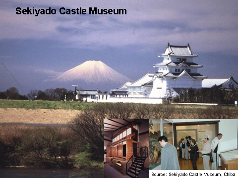
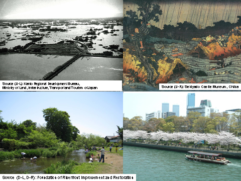
In this context I would like to introduce to you the Sekiyado Castle Museum located in Sekiyado, today’s Noda City, Chiba, located midstream of the Tone River (Figure 19). Sekiyado has served as the pivotal area for the Tone flood management as well as a place of strategic importance for Tone River inland navigation. In modern times, it had the benefit of using Dutch and other imported river engineering technology. The museum located at Sekiyado contains exhibits of the history of managing the Tone River flood as well as of the culture and industries nurtured by the River. Special exhibitions tell stories of people who lived with the Tone River. The exhibit “Overcoming Natural Disasters ~ History seen through Civil Engineering Legacies of the Tone River Basin at Midstream”, for example provides an excellent learning opportunity for the inhabitants of the basin to get to know their river.
The resolution of water issues must start with a profound realization of what water means to us. It requires a broad-based education as part of the “capacity building” of which we have spoken around the world so often. Needless to say, international conferences such as the World Water Forum will have a significant role to play in the resolution of these issues, while on the other hand we cannot forget the need for local initiatives like Sekiyado Castle Museum that help us learn from the history of people’s interaction with rivers.
4. In Conclusion
Water is an essential resource for human life and livelihoods. At times, however, it can play havoc with our lives. In our mountainous country with narrow downstream plains, it was essential for our survival that we control river basins as a whole in order to ensure sustainable development of the livelihood of our citizens. Efforts to this effect have been continued through the centuries.
Looking around the world, one sees there are different water crises from those we have experienced: increasingly severe natural disasters resulting from global warming, large scale water shortages, island states threatened by a rising sea level, increased flooding as a result of the melting of the Himalayan glaciers and so on.
We cannot fathom to what extent past human experience, such as those I shared with you, can be applied in meeting current challenges since suitable ways of managing water depend on specific conditions in each basin. Specific solutions have to be found in each of basins. There is, however, surely something we can learn from the lessons accumulated over time in the course of our efforts and failures in different parts of the world.
Too often we discuss the need to be better prepared right after the disaster but then conveniently forget about it. We have a saying in Japan “disaster strikes just when we had forgotten about it.” We must take necessary action before it is too late. We must be prepared. There is no panacea. The key is to constantly apply ourselves to put in place the required measures one at a time.
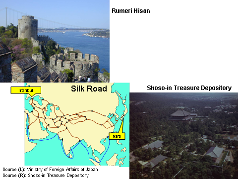
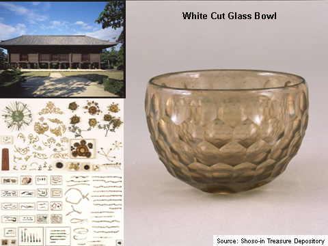
Istanbul is connected to Nara through the Silk Road (Figure 20). As a proof the Shoso-in Treasure Repository in Nara houses white cut glass bowls and vases made in Iran during the Sasan dynasty as well as crowns decorated with coral beads, which were worn by sovereigns in the 8th century. They are thought to have been carried over the great distance from the Mediterranean by way of Turkey. Having thought about the ties and interaction through the Silk Road over centuries, I am deeply moved at the opportunity of being with you in Istanbul (Figure 21).
Lastly, I would like to conclude my talk by praying that this World Water Forum will grapple with diverse issues that challenge peoples of the world, arrive at recommendations and reinforce actions to create an environment that enables sustainable access to safe drinking water and basic sanitation and the building of communities capable of managing water related disasters (Figure 22).
Thank you for your attention.
UNOFFICIAL TRANSLATION