The keynote lecture at the 4th World Water Forum by His Imperial Highness the Crown Prince of Japan
March 17,2006.Mexico.
Edo and Water Transport
Introduction
I am very pleased to be given this opportunity to present the keynote lecture at the 4th World Water Forum. I am to this day a student of water transport in medieval Japan and on the Thames in the 18th century. At the 3rd Water Forum which took place in Kyoto three years ago I focused on how Kyoto (Japan's capital for a thousand years from the 8th century) was efficiently served by water transport on the Yodo River and Lake Biwa. Today I thought I would focus on the water transport of Tokyo when the city was known as Edo (from the 15th to the 19th century) and how it contributed to the growth of the new capital. Behind this achievement lies a long history of the battle with water.
Incidentally, I did research on water transport on the Thames in the 18th century when I studied at Oxford University for two years from 1983. I observed how the Thames waterways and canals had contributed greatly to the development of the industrial revolution and the expansion of London, noting the engineering improvements made on the river itself, the nature of the goods transported and the actual conditions met by river traffic. What first caught my eye was the existence of locks in the rivers and canals. Since the locks relate to my talk today on Edo and Water Transport, I would like to begin by alluding to the rivers in England.
Locks and Rivers in England
Generally speaking, the interest in rivers in medieval England was to develop them as sources of power rather than as waterways. Rivers were dammed to create water head to turn the wheels of the flour mills and the depth required for weirs to trap fish. These resulted in incessant conflicts with barge operators who wanted to secure passage across dams and fish traps. The Thames was no exception.
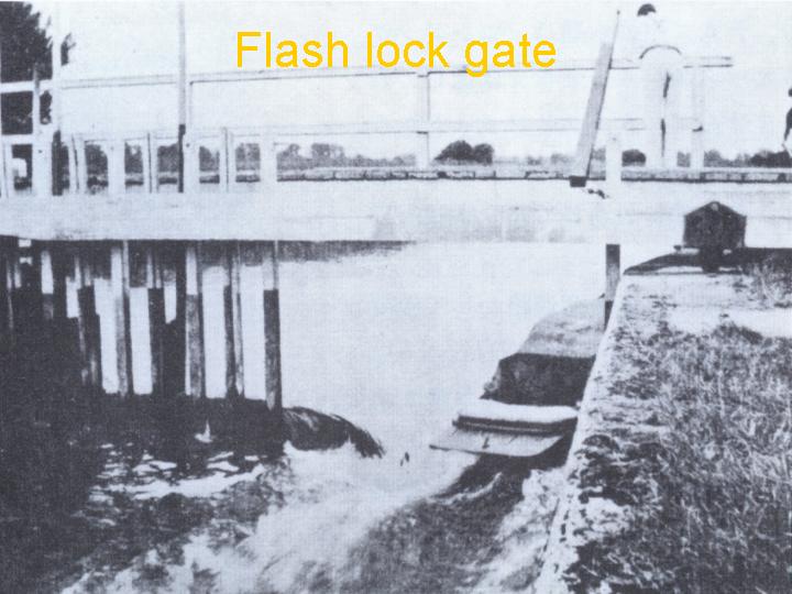
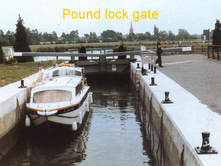
In the 13th century, flash locks appeared as a compromise between barge operators and millers. The lock gates would slide aside to allow vessels to pass (photo-1), unleashing a torrent of water that barge captains had to navigate with great care (photo-2), at times unsuccessfully. Moreover, it took time to regain the desired level of water to turn the mill wheels again. The urban expansion of London and rural development in the 17th and 18th centuries emphasized the importance of rivers as waterways. A technological solution was found to this conflict of interests between the shippers and the millers. Impressive pound locks were developed which are found on many canals and rivers to this day (photo-3). The Panama Canal uses this system.
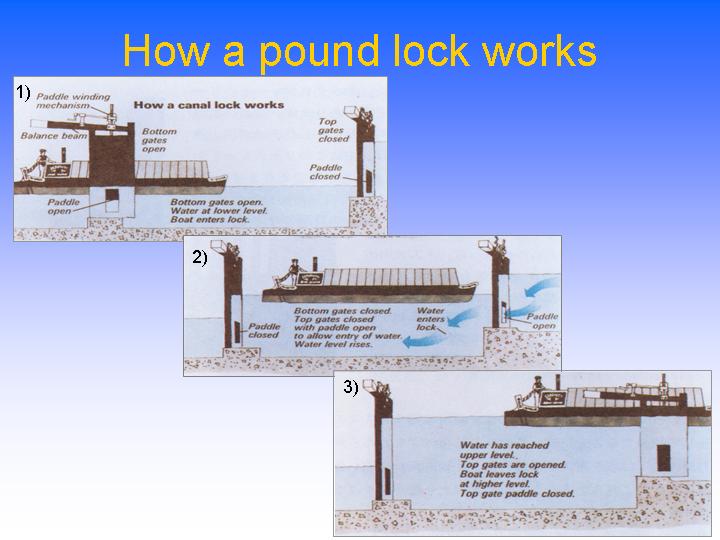
The pound lock (fig-1) has a wooden water gate at either end of chamber walls constructed of stone or bricks. Small gates called paddles are utilized to help control the raising and lowering of the water level within the chamber to equal that of the river or canal to allow vessels to proceed. The invention of the pound lock allowed ships to navigate fast-flowing waterways without using a great volume of water. Three such pound locks were installed on the Thames in the 1630s. These locks posed no particular problems except that when a number of these locks were placed in close proximity, a large reservoir had to exist upstream in order to supply the amount of water needed to operate them.
The establishment of these pound locks, improvements in river regulation and the construction of canals all facilitated the growth of water transport, which in turn assisted in the industrialization of England. In recent times, however, there has been a great increase in the use of the waterways for leisure and recreation. Many people own and navigate private boats up and down the rivers and canals, at times having to negotiate the pound locks. The photo (photo-4) was taken when I helped to open a canal lock gate in my cruising from Oxford Canal to Thames River with my friends from Oxford University during my study in England.
Now it seems there are moves to use canals to develop water supplies. In regions where shortage of water is becoming serious, there is talk of using canals to supply water from areas where it is more abundant to those that are short of it. Incidentally, it has been calculated that in this way water can be supplied at one-tenth the cost of installing a new pipeline and one-seventh the cost of operating one. The operation basically requires a pump and the ability to change the flow of water at critical junctures. The heritage of the industrial revolution appears to be reviving through these novel uses, whether for leisure or for supplying water.
Edo and Water
On returning home from Oxford continued my research on water transport and found that by the beginning of the 18th century locks had been built and used in Japan as well. It was a pleasant surprise to find that Japan's oldest lock was located in present day Saitama Prefecture contiguous to northern Tokyo. In fact, the construction of the lock was the culmination of a prolonged battle with water. The canal where it was located, Minuma tsusen bori, was truly the symbol of that struggle.
Let me tell you a little about Tokyo when it was still called Edo.
Eastward diversion of the Tone River
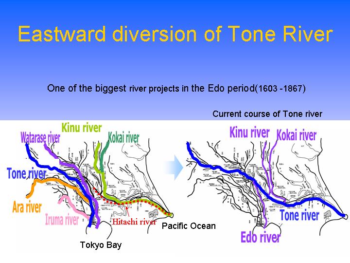
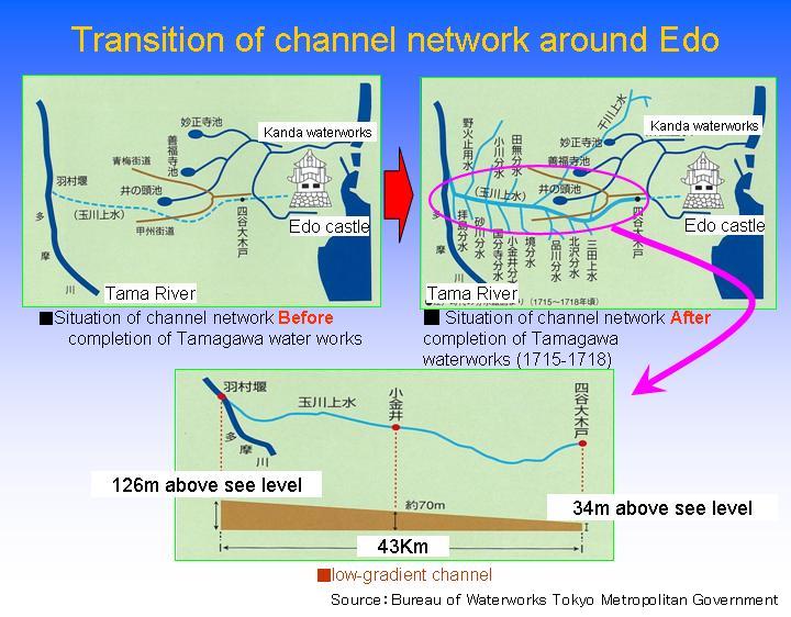
As 17th century dawned, the warlord Tokugawa Ieyasu established the Edo Bakufu, or Shogunate. That was in 1603. Edo remained the seat of Tokugawa government until the Meiji Restoration in 1868. In establishing the Shogunate, Ieyasu embarked on a project to protect Edo from water hazards. In those days there were two rivers flowing through Edo, the larger of which was the Tonegawa, and the other the Arakawa, which was notorious for breaking its banks and overflowing. Nearby inhabitants thus were often exposed to the danger of flooding. Ieyasu diverted the Tonegawa in stages towards the east, separating it from the Arakawa to protect Edo from floods (fig-2). As a result of this initiative the Tonegawa now flows directly to the Pacific Ocean rather than into Tokyo Bay as it originally did. This was called “Tosen”, or the Eastward Relocation of the Tonegawa.
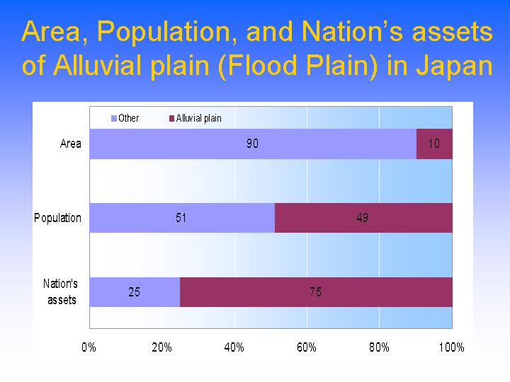
This is but one example of how our people managed the land to protect it from water hazards, whether overflowing rivers or high tides, making it habitable. As a consequence of similar interventions, (fig-3) 50% of all Japanese live on the alluvial plains which representing 10% of the country's land area and where 75% of the nation's assets are also concentrated.
Development of Minuma Tamei
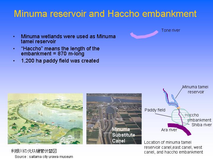
The diversion of the Tonegawa created vast wetlands (fig-4). The Minuma, which is today part of Saitama City in Saitama Prefecture adjacent to Metropolitan Tokyo, suffered a drop in its water level when the Tonegawa was diverted. In 1629, an 870 meter-long embankment was constructed to create a 1,200 hectare irrigation reservoir, called the Minuma Tamei. A local magistrate, Ina Tadaharu, directed the operation using a construction method known as “Kanto Ryu” or the Kanto Way (fig-5), which supplied water to the existing marsh. This contributed to the development of the area, particularly downstream of the embankment. However, with the expansion of cultivated land the water held in the reservoir was not always sufficient. At other times following torrential rainfall the rice paddies were submerged under water that overflowed from the reservoir.
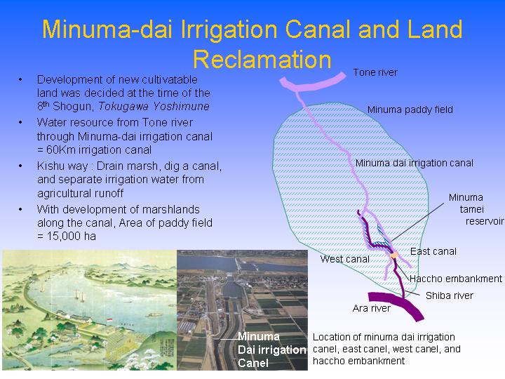
Since the shogunate was established in the beginning of the 17th century, Edo became the preferred residential site for the shogun, some feudal lords and their vassals and families, as well as Buddhist monks and Shinto priests, and merchants, tradesmen and artisans. A century later, Edo had a population of over a million. Needless to say, there was a need to supply the large population of consumers. Goods supplied by sea from the commercial city of Osaka filled the gap but the newly developed agricultural hinterlands of Edo contributed as much. At the time of the 8th shogun, Tokugawa Yoshimune (who lived from 1684 to 1751 and ruled from 1716 to1745), it was decided that new cultivatable land would be developed because the shogunate needed increased revenues. The possibilities offered by the Minuma Tamei reservoir could not be overlooked, and land reclamation by drainage was begun. The 8th shogun, who came from present day Wakayama Prefecture, appointed Izawa Yasobei (born in 1654, died in 1738), an accountant of the shogunate and a civil engineer by training, to direct the design and operation of the plan. So, a 1,200 hectare rice paddy emerged where the 1,200 hectare reservoir had been.
Minuma-dai Irrigation Canal
(fig-6) The embankment of the Minuma Tamei reservoir was demolished and the water was drained to the Arakawa River via the Shibakawa River (formerly a drainage canal). After the reservoir was drained to create new rice paddies, there was a need to tap another source of water for irrigation. For this, water would be drawn from the Tonegawa, and a 60-kilometer irrigation canal was constructed. The shogunate thus obtained sufficient water to irrigate a new area of paddy as well as the existing rice fields. The canal was called Minuma Dai-yosui - the Minuma Substitute Irrigation Canal. Rice yield doubled with the completion of the canal compared to when the Minuma was marshland. At the same time, marshlands along the canal were also developed to become one of Japan's major rice-growing areas. Covering 15,000 hectares, it is known today as the Minuma Rice Fields (Minuma Tanbo). Izawa Yasobei's method of draining the marsh and digging a new canal and of separating irrigation water from waste water, was called the Kishu (Wakayama) way in contrast to the Kanto Way.
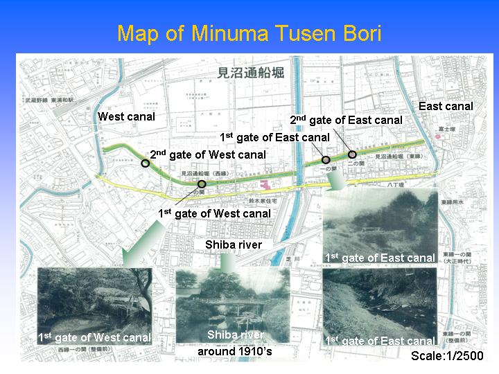
Minuma Tusen Bori (barge canal)
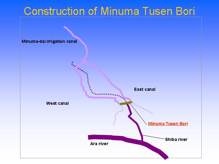
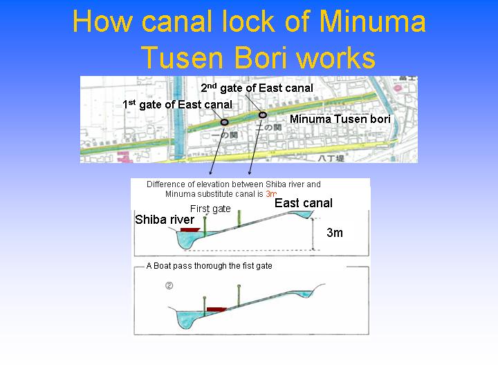
Izawa thought it necessary to link the vast agricultural area with the mega city Edo by water transport. However, while the Minuma Canal flowed strongly in its higher reaches, volumes were reduced farther down after the irrigation water had been drawn off, making it unsuitable for transport(fig-7). At the same time, the waste water canal became fuller as it flowed downstream and collected more drainage from the fields. Izawa came up with the idea of connecting the irrigation canal with the drainage canal. The problem was that there was a water level difference between them of 3 meters. To overcome this discrepancy the Minuma barge canal was built (photo-5).
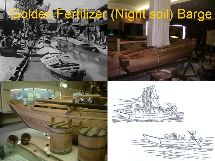
The canal was dug in 1731 to enable the passage of vessels between the drainage canal, the Shibakawa, and the two irrigation canals to the east and the west(fig-8). Japan's first wooden two-stage lock gate was installed to solve the challenge of the 3-meter water level differential. Unfortunately, this lock gate has not survived. What we have today is a replacement. The barge canal, which overcame the 3 meter difference between the irrigation canals and the Shibakawa, became the most important means of transporting produce and other goods to and from Edo and the Minuma region. It was used mainly in winter when irrigation was not needed. Rice, vegetables and timber were shipped out of the Minuma fields. From Edo went fertilizer, soy oilcake, fish and salt. Its most important export was fertilizer, which in those days was night soil. It was called ‘golden fertilizer’ and was handled with respect. A special barge was built to transport this valuable commodity. Today, we would say it was recycled (fig-9). The golden fertilizer barges were in service even up to the Showa era (1926-1989).
So Edo, which by then had become a big city, was a recycling community. It was a remarkable feat, considering that elsewhere, as Victor Hugo was lamenting in “Les Miserables”, night soil was being dumped in the river. It is no surprise, then, that foreign visitors to Edo marveled at the cleanliness of the city.
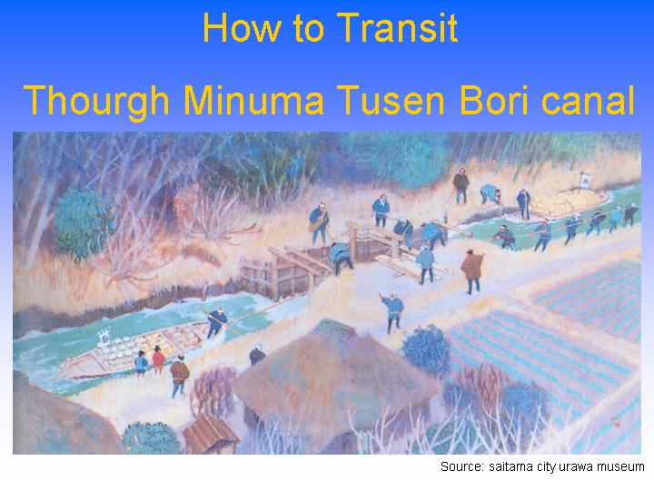
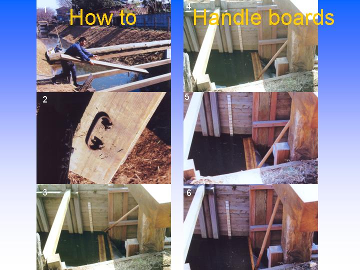
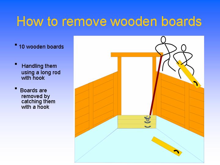
Let me discuss the mechanical aspects of the Minuma Barge Canal (fig-10). 1) Two lock gates were built to overcome the 3-meter difference in the water levels of the Shibakawa River and the irrigation canal. 2) When the vessel passed through the first lock, manpower was used to pull the boat through the swift water of the canal (fig-11). 3) When the boat had passed the first lock gate, boards were placed to raise the water level. I will show you how it works (fig-12). A wooden board is thrown into the canal. The flowing water takes the board to the two pillars of the lock gate. The board has a handle that is caught with a long hooked rod and manipulated using the force of the water to a horizontal position between the two pillars. The procedure is repeated until ten or so boards are in place one above the other. 4) The water level is thus raised high enough for the vessel to pass the second gate (photo-6). To lower the water level, the boards are removed one at a time by catching them with a hook as before (fig-13). Unlike the lock gates in Europe that are mechanically opened and closed, the manually operated system is uniquely Japanese. The Minuma Vessel Lock Gate is one that makes a unique contribution to world history.
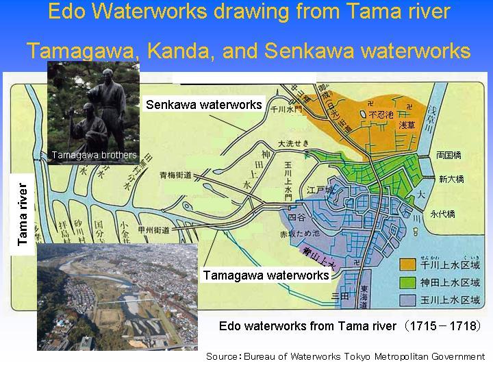
Edo Waterworks drawing from the Tama River (Tamagawa)
Ensuring drinking water for its large population was a major challenge for Edo. The difficulty of penetrating the hard ground of the Kanto Plains was a formidable obstacle to exploiting the use of underground water. In the days when power was not available it was difficult to draw a large quantity of water from a nearby river as levels were usually too low. Water for drinking and household use therefore was drawn from lakes or farther upstream. The Kanda waterworks in Edo (fig-14) drew water from three lakes, Myoshoji, Zenpukuji and Inokashira, and supported the life of the Shogun and the city population. Later, in 1654, the Tamagawa brothers operated the Waterworks drawing water from the Tama River. The water was abundant and was transported in an open channel over 43 kilometers from Hamura on the river where it was drawn to Yotsuya-Okido. At Senkawa and at other locations the water was diverted in catchments to supply the citizens of Edo, and without any doubt, contributed to the city's growth (fig-15).
The water used in Tokyo today is drawn from the same sluice from which the Tamagawa Waterworks drew and is distributed via the Yamaguchi and Murayama reservoirs. The Tamagawa Waterworks is no longer in service but the idea of drawing water at Hamura village on the Tama River for distribution is still viable. In 1962, a plan was announced to draw water from the Minuma irrigation canal to makeup for the shortage in Tokyo. It seems to me that, while no longer in service, the concepts pioneered in the Minuma Barge Canal and the Tamagawa Waterworks are still very much a part of our lives today. The canals in England that I had the pleasure to visit continue to live on with new roles, providing places for leisure and as sources of water. In France, the Midi Canal, registered in 1996 as a world heritage site, is in daily use while at the same time all its original mechanisms are preserved.
In Conclusion
I have shared with you some illustrations of the special relations man has with water, with reference to the Thames, hinterland developments serving Edo, and water transport and waterworks that have contributed much to make the present-day Tokyo.
Water management represents a major challenge today. The solutions require an urgent commitment and cooperation in partnership among all members of the international community. But it must be noted that any solution to be effective must identify and meet the distinct needs of each region and every river basin. It is probably best found in the wisdom accumulated over millennia by local inhabitants. That is to say, only when regional traditions and histories are respected can solutions be truly useful.
When I stand by the Minuma Barge Canal, I feel that it is beckoning to us in Japan and elsewhere as we take on the challenges of water. One can surely find comparable pioneering achievements in every region of the world. To preserve them and draw inspirations from them seems to me the best way to find solutions wherever we are.
Thank you so much for your attention.
To a list of documents(Open this content in a new window)
UNOFFICIAL TRANSLATION