Memorial Speech for The 3rd World Water Forum by His Imperial Highness the Crown Prince of Japan
Waterways Connecting Kyoto and Local Regions
-Focusing on Ancient and Medieval Water Transport on Lake Biwa and Yodo River-
Introduction
Today, I would like to speak about the city of Kyoto, where we are gathered today, and its relation to water transport, encapsulating the period from the late 8th century, when Kyoto became the capital, to the 15th century.
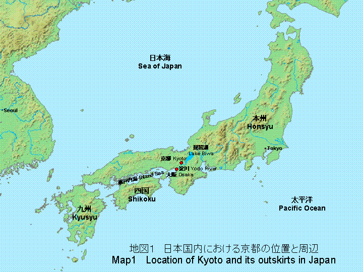
Before Kyoto became the capital, the capital was located at Nara, which is to the south of Kyoto(Map 1). Nara is home to Todaiji temple, which is famous for its Great Buddha, and Horyuji, which has been designated as a world heritage site.
Kyoto became the capital, known as Heian-kyo, in 794. It remained the capital for about 1000 years, until 1868 when, with the Meiji Restoration, the capital was transferred to Tokyo.
Kyoto is an inland city, so you may be somewhat mystified to hear that it was a major hub for water transport in Japan. First of all, I would like to confirm Kyoto’s geographical location using Map 1 from the perspective of water transportation.
Setonaikai, or the Inland Sea of Japan, is located to the west of Osaka Prefecture, which neighbors Kyoto. The Inland Sea is surrounded by the islands that comprise the Japanese Archipelago: Honshu, Shikoku and Kyushu. The waters of the Inland Sea are relatively calm, and with its hinterland of salt-producing regions, forested regions and agricultural regions, the Inland Sea has functioned as the main artery for the distribution of goods.
The tributaries of the Yodo River that flow into Osaka Bay-Katsura River, Kamo River and Uji River-run through present-day Kyoto. In other words, the Inland Sea and Kyoto are connected by these rivers.
In addition, to the east of Kyoto lies Lake Biwa, the largest lake in Japan, which is in central Shiga Prefecture. Lake Biwa spans approximately 50 kilometers from north to south. As the crow flies, it is approximately 20 kilometers from the northernmost tip of Lake Biwa to the Sea of Japan. Furthermore, a major highway has passed the east of Lake Biwa on its way to eastern Japan since ancient times. If you look at this situation, I am sure that you will understand that Kyoto fulfilled all the geographical conditions necessary for relatively easy access. Kyoto is connected to the Inland Sea via Yodo River to the west, which in turn connects it to the various regions of western Japan. On the east, Kyoto is connected to the Sea of Japan and eastern Japan via Lake Biwa.
I have heard that this Third World Water Forum will take up water transport of Lake Biwa and Yodo River as one of the agenda items. I believe that given what I have just explained and considering Kyoto’s location, it is easy to imagine the significant role played by water transport of Lake Biwa and Yodo River.
I would now like to take a look at water transport of Lake Biwa and Yodo River in greater detail.
Water transport on Lake Biwa
First, I would like to talk about Lake Biwa. Lake Biwa has an area of 673.9 sq.km. It is Japan’s largest lake and it has played a significant role in water transport.
In discussing water transport, I believe it is necessary to talk a little about the distribution of goods at around the time when Kyoto became the capital of Japan.
Transportation of state tributes and water transport on Lake Biwa
Prior to Kyoto becoming the capital, from the period when Nara, or Heijo-kyo, was the capital, the central government collected state tributes from regional governments to maintain the government and secure revenue (Map 1). As for the types of state tributes, they could be roughly categorized as follows. Heavy freight such as rice comprised the bulk of state tributes from regions along the Sea of Japan and the western regions. On the other hand, light freight such as silk and cotton comprised the state tributes from eastern Japan. It can be thought that the reason for this was that the Sea of Japan and the Inland Sea were suited for navigation and also because water transport on Lake Biwa could be used. In addition, in eastern Japan, regions which faced the Pacific Ocean had rougher waters and thus were not suited for navigation. For this reason, goods were transported by land instead. After the capital was transferred to Kyoto, a document that clearly describes the situation concerning the transport of state tributes, a collection of statutes known as the Engishiki, was compiled at the beginning of the 10th century. The Engishiki clearly stipulates the content and shipping charges for state tributes that came into the capital, as well as transport routes.
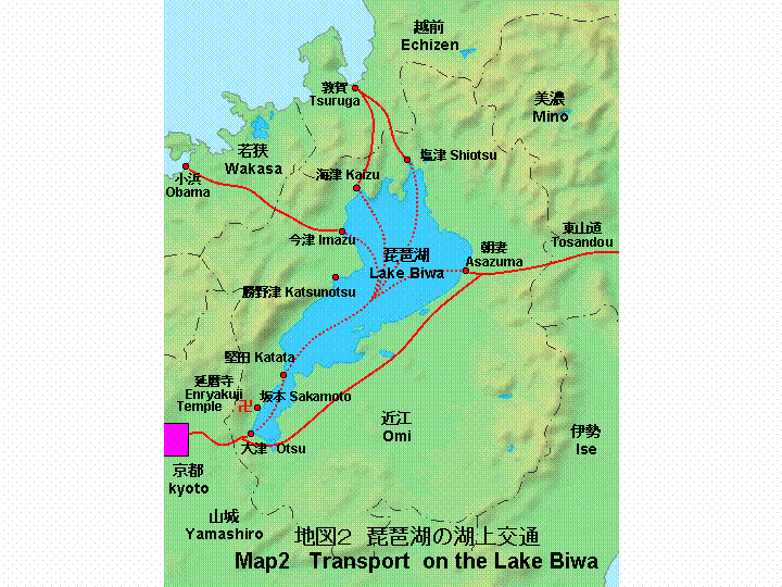
Please take a look at Map 2. According to the Engishiki, tributes from northern regions were transported by sea to Tsuruga (present-day Tsuruga City, Fukui Prefecture) and transported by land to Shiotsu, a town located on the northern shore of Lake Biwa. The tributes were then brought to Otsu by water transport on Lake Biwa and finally to Kyoto by land transport. Incidentally, the distance between Shiotsu and Otsu is approximately 60 kilometers by ship. Tributes that came from Wakasanokuni(present-day Fukui Prefecture) located northwest of Lake Biwa were transported by land to Katsunotsu(present-day Takashimacho), located on the western shore of Lake Biwa. From there, the tributes were transported by water on Lake Biwa to Otsu.
The tributes from eastern Japan were carried mainly along the Tosando, "eastern mountain road," which was the main route from eastern Japan, gathered at Asazuma (present-day Maibaracho), located to the east of Lake Biwa, and were transported to Otsu from there.
As you can see, Otsu played a very important role as a goods distribution center on Lake Biwa. Incidentally, Otsu was established as a capital called Otsu-kyo by Emperor Tenji in 667, who was the great-grandfather of Emperor Kammu, the founder of Heian-kyo. When Otsu-kyo ceased to be the capital in 672, its name was changed to Kotsu, which meant "old port". It was renamed again, becoming known as Otsu as it came to play a vital role as an outlying port for Kyoto when that city became the capital.
Transporting annual feudal tributes and water transport on Lake Biwa
From the 10th century when the Engishiki statutes was compiled, a feudal system developed in which land that had previously belonged to the state became the private property of influential shrines, temples and nobles. Under this system, nobles residing in Kyoto and influential shrines and temples located in Kyoto collected annual tributes, which served as revenue, from the manors that they owned in various parts of Japan. The goods that served as tributes consisted mainly of rice, but depending on the location, salt, silk, cotton and iron were also collected. They were sent to Kyoto on an annual basis.
It was at this stage that distributed goods switched from being state tributes to annual feudal tributes.
First I would like to introduce the relationship between the transport of annual feudal tributes and water transport on Lake Biwa(Map 1).
Annual tributes from regions facing the Sea of Japan such as Echigo, Noto, Kaga and Echizen(the areas known today as Niigata Prefecture, Ishikawa Prefecture and Fukui Prefecture) were brought via sea routes to Tsuruga or Obama (please look at Map 2 again). The tributes were then transported by land to the northern ports of Lake Biwa such as Shiotsu, Kaizu and Imazu. From there they were brought to Otsu and Sakamoto via Lake Biwa and finally to Kyoto by horse-back or by cart. By the way, most carts at the time were pulled by ox or people. Horse-drawn carriages were not introduced to Japan until after the middle of the 19th century when, in the Meiji Period, the capital was transferred to Tokyo.
For example, Toji temple in Kyoto possessed estates in Taranosho, Wakasanokuni, located in present-day Obama City, and collected an annual tribute in rice. This rice was delivered from Taranosho to Imazu, located northwest of Lake Biwa, by land. It was then brought to Otsu using water transport on Lake Biwa and then to Toji temple by land transport again.
Another example is that of the town of Sakamoto (in present-day Otsu City), close to Enryakuji-temple located on Mt. Hiei. This town thrived as a point where the annual tributes from Enryakuji’s land possessions were gathered. Enryakuji-temple was built in the late 8th century. It was an esoteric Buddhist temple belonging to the Tendai Buddhist sect and possessed many feudal estates throughout Japan.
As water transport on Lake Biwa developed in this way, many customs checkpoints were built in order to collect customs from boats that were passing through. Many of the customs checkpoints were owned by Enryakuji-temple and the customs that were collected were used for constructing buildings by the temple. In the 15th century, Enryakuji-temple owned 11 customs checkpoints on the shores of Lake Biwa. The customs that were levied were about one-hundredth of the freight.
Furthermore, Katata, which is now in Otsu City, is situated where Lake Biwa is narrowest, and served as a staging point for boats from around the 11th century and was an important location from ages past (please see Map 2). In Katata, there were people called "Katata-shu," who ensured the safety of boats in Lake Biwa in return for an escort fee. "Katata-shu" enjoyed tremendous privileges in water transport on Lake Biwa.
In Europe and other places, medieval cities still exist that are surrounded by water and canals. It is said that medieval Katata had the same sort of scenery, as a town of canals fed by the waters of Lake Biwa.
Water Transport on the Yodo River
Next, I would like to talk about water transport on the Yodo River. Facing west from Kyoto, the Yodo River plays an important role in linking Kyoto and the Inland Sea.
Characteristics of Japanese rivers
Before speaking about the Yodo River, I would like to briefly introduce the characteristics of Japanese rivers from their relationship to water transport.
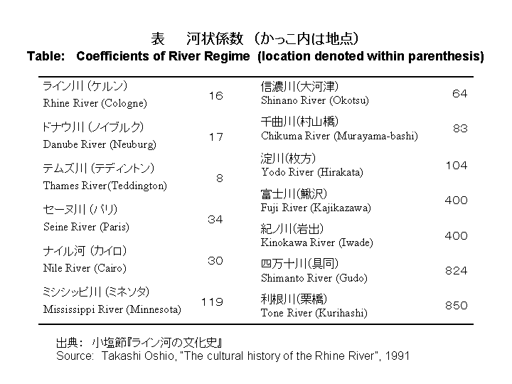
Please look at the table. This shows a comparison between the flow of rivers in the world and that of the main Japanese rivers using the coefficient of river regime.
The coefficient of river regime is the ratio of a river’s flow volume at its maximum to the minimum flow volume. The smaller is the figure, the more stable is the volume of water flow through the year. By looking at this coefficient, it can be understood how stable the flow of a river is. For example, the coefficient of river regime measured at the city of Cologne along the Rhine River is 16, at Teddington near London along the River Thames the coefficient of river regime is 8. In contrast, the flow volume of Japanese rivers varies greatly throughout the year and the coefficient of river regime for them is high. The coefficient for the Yodo River, which I will talk about today, measured at Hirakata in Osaka Prefecture is 104. From this, we can understand that the flow volume of Japanese rivers varies greatly throughout the year. It can be seen from the fact that Japanese rivers have dry riverbeds as floodplains, whereas these are rarely seen in the rivers of Europe. I think you can understand that the unstable flow volume of Japanese rivers is not necessarily suited for water transport.
Yodo River and the transport of state tributes
Such characteristics notwithstanding, the Yodo River has, as a river on which navigation was possible since ancient times, performed a significant function in the transport of people and goods.
Please look at Map 3. This shows the Yodo River basin during the period of Heian-kyo. First, in terms of the transport of state tributes, as I referred to earlier, according to the Engishiki, boats from various regions in western Japan would sail on the Inland Sea and upstream along the Yodo River, to the town of Yodo near present-day Fushimi Ward in Kyoto, where they would moor and unload their cargos.
The town of Yodo was situated at the present-day starting point of the Yodo River, and the point at which the Katsura River, the Uji River which has its source at Lake Biwa and the Kizu River merged. If you look at the map, there is a point at which these three rivers merge, and there was a large pond called the Ogura Pond which does not exist now. The town of Yodo was located here on a sandbar, and this served as an outer harbor for Heian-kyo. It seems that at that time, ferries would come and go from the sandbar.
The state tributes collected at Yodo were transported by land using horses and carts and delivered to the warehouses of the Ministry of Finance in Heian-kyo.
Yamasaki, which was near Yodo, also served as a storage places for goods. Lake Biwa’s Otsu, and Yodo and Yamasaki on the Yodo River served as outer harbors for Heian-kyo.
Furthermore, it has been said that in establishing official rice prices in those days, the rice prices in Otsu, Yodo and Yamasaki were taken into account. These places were more than just places where rice was collected. They were places at which rice dealing, which had a direct effect on the economy of the capital and the state, took place.
Transport of annual feudal tributes, travel and water transport on the Yodo River
Later, as the feudal system developed, the town of Yodo became an important harbor for the unloading of feudal tributes. For example, on the island called Yugejima in the Inland Sea, there was a manor owned by Toji temple of Kyoto that gave an annual tribute of the salt. The annual tribute of salt, after it was brought from the Inland Sea upstream on the Yodo River and unloaded, was transported over land to Toji temple. Also, from around the 13th century, there was a wholesale market at which the dealing of salt and seafood was held. It was here that boats sailing upstream on the Yodo River, which had carried salt and salted seafood, were forced to land. Traveling upstream by boat from the mouth of the Yodo River to the town of Yodo was to take one whole day.
Up until now, I have talked about the annual tributes and goods that traversed the Yodo River, but the Yodo River was also used for the transportation of people. For example, after the beginning of the Heian Period, Kumano and Mt. Koya in the southern Kii Peninsula(Map 1) became a place of pilgrimage. For pilgrimage, boats leaving from Yodo and Yamasaki went downstream and went out into the ocean and sailed to the ports nearest to the destination along maritime routes. If you look at records from the time, when water levels in the Yodo River were low, banks were dug and markers were grounded in the water routes, and at places that were especially difficult to navigate, one solution was to make a bundle of reeds or stack small pieces of wood and build dams to change the flow of the river.
The records show that when the boats were sailing, there were no problems going downstream, but when facing upstream, groups of people would pull the boats up by ropes. In medieval Europe, sailing boats were tied with ropes and pulled with horses. For this reason, roads called footpaths were built along both sides of rivers. To my knowledge, however, in medieval Japan there were no examples of horses pulling river boats.
Also, in the mid-15th century, based on pictures showing sailboats on the lower river basin of the Yodo River, we know that windpower was also used as a driving force.
Yodo River and waterway customs checkpoints
I spoke about water transport on Lake Biwa earlier, but likewise on the Yodo River as well, as the amount of transport grew, so did the establishment of customs checkpoints on the banks of the river.
On Lake Biwa, I mentioned that the customs checkpoints were built for the purpose of the construction of buildings by Enryakuji-temple. In the case of the Yodo River, at the end of the 15th century, it is said that almost 400 customs checkpoints had been erected by court nobles in Kyoto and temples and shrines of Nara. It is said that the length of the Yodo River until the river mouth, is about 50 kilometers, and for that distance, 400 checking stations is a considerable number. It is difficult to imagine all the boats stopping at almost 400 places to pay a tax. Therefore it is thought that customs checkpoints at which boats had to stop were determined by the type of their freight.
That said, the proliferation of such customs checkpoints was a significant impediment to transportation at the time. In response to these developments, the shogunate which held power at the time sought to reduce the number of customs checkpoints, and some transporters committed acts of vandalism against the checkpoints. However, it was not until the emergence of Toyotomi Hideyoshi at the end of the 16th century that all customs checkpoints were finally abolished.
Conclusion
We have taken a brief look at water transport on Lake Biwa and the Yodo River from the time Heian-kyo was established at the end of the 8th century to the 15th century. I hope that you understand how the city of Kyoto was linked to the Sea of Japan and eastern Japan by Lake Biwa to the east, and in the west, it was linked to the western regions of Japan by the Yodo River.
Today, with developed land transport, it is easy to forget about transport on lakes or rivers. However, I think that water transport was the best method to move large loads of people and goods in an inexpensive way. Also, since I traveled on the River Thames several times, while I was studying at Oxford University in the United Kingdom, I have become quite familiar with rivers. From a boat , we can command a view which is often wider in scope and more scenic than the ones from land. I hope that in Japan also the people feel closer to the water, and give a fresh look at the potentialities of water transport. In concluding my presentation, I wish to express my sincere hope that the beauty of lakes and rivers in not only Japan but also around the world will be preserved for a long time to come.
UNOFFICIAL TRANSLATION